|
search place name
|
||
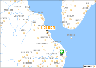
Lalaan (Negros Oriental, Philippines)Lalaan is a town in the Negros Oriental region of Philippines. An overview map of the region around Lalaan is displayed below.
regional and 3d topo map of Lalaan, Philippines ::
Lalaan airports ::
The nearest airport is DGT - Dumaguete, located 8.8 km south east of Lalaan.
Other airports nearby include NOP - Masbate Mactan Cebu Intl (128.6 km north east), BCD - Bacolod (142.3 km north), ILO - Iloilo (164.9 km north west), LGP - Legazpi Pagadian (175.0 km south), Nearby towns ::
Calo (0.5km south east) //
San Jose (2.3km north west) //
Ajong (2.6km south east) //
Maningcao (2.6km south west) //
Ayuquitan Viejo (3.0km north west) //
Tapon Norte (3.0km north west) //
Looc (3.7km south east) //
Cambaloctot (4.3km south west) //
Basiao (4.5km north west) //
Cantamoay (4.6km north west) //
Jilocon (4.6km north west) //
Magatas (5.1km south east) //
Villanueva (5.3km south west) //
Sibulan (5.5km south east) //
Tampi (5.6km north) //
Basac (5.7km west) //
Tambojangin (6.3km north) //
Cangipus (6.3km south) //
Siapo (6.3km north west) //
Tubtuban (6.5km south east) //
Maslog (6.6km south east) //
San Antonio (6.7km south) //
Tandayag (6.7km north) //
Liloan (7.1km north east) //
Amlan (8.0km north) //
Bolocboloc (8.1km south east) //
Looc (8.3km east) //
Malabo (8.6km south west) //
Cancawas (8.7km north west) //
[all distances 'as the bird flies' and approximate]  Places with similar names to Lalaan, Philippines ::
Disclaimer :: Information on this page comes without warranty of any kind |
||
|
Where is Lalaan? Elevation and coordinates ::
Latitude (lat): 9°23'47"N Longitude (lon): 123°15'6"E
Elevation (approx.): 37m (map arrows pan, magnifying glasses zoom) |
||
|
Visiting Lalaan? Hotel/Accommodation ::
Book a hotel in Lalaan Travel Guide ::
Buy a travel guide for Philippines rental cars ::
car rental offers GPS waypoint ::
download a GPX waypoint (PoI) of Lalaan for your GPS receiver
|
||