|
search place name
|
||
Landusan (Northern Samar, Philippines)Landusan is a town in the Northern Samar region of Philippines. An overview map of the region around Landusan is displayed below.
regional and 3d topo map of Landusan, Philippines ::

Landusan airports ::
The nearest airport is TAC - Tacloban Daniel Z Romualdez, located 164.3 km south east of Landusan.
Other airports nearby include KLO - Kalibo (209.5 km south west), BCD - Bacolod (238.0 km south west), ILO - Iloilo (257.8 km south west), Nearby towns ::
Sawang (3.1km south east) //
San Luis (3.8km north) //
Capul (4.1km east) //
Linungsuran (4.2km south east) //
Sangputan (10.3km south west) //
[all distances 'as the bird flies' and approximate] 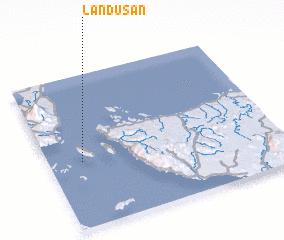 Places with similar names to Landusan, Philippines ::
// Linadasan (PH)
// Landzāni (LV)
// Landusane (MZ)
// Lien-ts'un (TW)
// Lin-nei-ts'un (TW)
// Lin-tzu-nei (TW)
// Lindåsen (SE)
// Lindåsen (SE)
// Lindåsen (SE)
// Lontzen (BE)
Disclaimer :: Information on this page comes without warranty of any kind |
||
|
Where is Landusan? Elevation and coordinates ::
Latitude (lat): 12°25'48"N Longitude (lon): 124°8'36"E
Elevation (approx.): 16m (map arrows pan, magnifying glasses zoom) |
||
|
Visiting Landusan? Hotel/Accommodation ::
Book a hotel in Landusan Travel Guide ::
Buy a travel guide for Philippines rental cars ::
car rental offers GPS waypoint ::
download a GPX waypoint (PoI) of Landusan for your GPS receiver
|
||