|
search place name
|
||
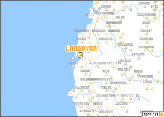
Lang-ayan (Ilocos Sur, Philippines)Lang-ayan is a town in the Ilocos Sur region of Philippines. An overview map of the region around Lang-ayan is displayed below.
regional and 3d topo map of Lang-ayan, Philippines ::
Lang-ayan airports ::
The nearest airport is BAG - Baguio, located 102.5 km south of Lang-ayan.
Nearby towns ::
Sabangan (0.0km north) //
Baraoas (0.0km north) //
Bulbulala (1.9km south) //
San Roque (1.8km west) //
Guinabang (1.8km east) //
Nalasin (1.8km east) //
Matanobong (1.9km north) //
Olo-olo (1.8km east) //
Santiago (2.1km north east) //
Gabao (2.6km south west) //
Ambocao (2.6km north west) //
Apatot (2.6km north west) //
Mambug (2.6km north east) //
Butol (2.6km south west) //
Big-Big (3.7km north) //
Dan-ar (3.7km south) //
Caborao (4.1km south east) //
Al-Aluding (4.0km south east) //
Salincub (4.0km south east) //
Ubbog (4.0km south east) //
Ansad (4.1km north east) //
San Nicolas (4.1km north east) //
San Esteban (5.0km north) //
Banao (5.1km north east) //
Tamorong (5.6km north) //
Llang (5.6km north) //
Langlangca Segundo (5.8km south) //
Balingaoan (5.8km south) //
San Rafael (5.8km north) //
[all distances 'as the bird flies' and approximate]  Places with similar names to Lang-ayan, Philippines ::
Disclaimer :: Information on this page comes without warranty of any kind |
||
|
Where is Lang-ayan? Elevation and coordinates ::
Latitude (lat): 17°17'0"N Longitude (lon): 120°26'0"E
Elevation (approx.): 3m (map arrows pan, magnifying glasses zoom) |
||
|
Visiting Lang-ayan? Hotel/Accommodation ::
Book a hotel in Lang-ayan Travel Guide ::
Buy a travel guide for Philippines rental cars ::
car rental offers GPS waypoint ::
download a GPX waypoint (PoI) of Lang-ayan for your GPS receiver
|
||