|
search place name
|
||
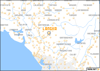
Langka (Bulacan, Philippines)Langka is a town in the Bulacan region of Philippines. An overview map of the region around Langka is displayed below.
regional and 3d topo map of Langka, Philippines ::
Langka airports ::
The nearest airport is MNL - Manila Ninoy Aquino Intl, located 25.9 km south of Langka.
Other airports nearby include BAG - Baguio (185.1 km north), Nearby towns ::
Lawang Bato (0.7km south) //
Libtong (0.8km west) //
Lawa (1.6km west) //
Perez (2.0km north east) //
Iba (2.2km north) //
Bignay (2.2km east) //
Malajacan (2.4km west) //
Bahay Pare (2.4km west) //
Calabingcoho (2.4km west) //
Quipandan (2.7km south) //
Quepandan (2.7km south) //
Liñgunan (2.8km south west) //
Calvario (2.7km west) //
Meycauayan (2.9km west) //
Bagbaguin (3.0km south east) //
Pandayan (3.0km north west) //
Lias (3.4km north west) //
Kanumay (3.5km south west) //
Paso de Blas (3.7km south) //
Pintong Dayap (3.6km north west) //
Santa Rosa (3.6km north west) //
Bagbaguin (3.8km north east) //
Saluysoy (3.8km west) //
Bañga (3.9km south west) //
Camalig (4.0km north) //
Kaybiga (4.0km south east) //
Malanday (4.1km south west) //
Nagbalon (4.2km west) //
Parada (4.6km south) //
[all distances 'as the bird flies' and approximate] 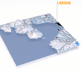 Places with similar names to Langka, Philippines ::
Disclaimer :: Information on this page comes without warranty of any kind |
||
|
Where is Langka? Elevation and coordinates ::
Latitude (lat): 14°44'27"N Longitude (lon): 120°59'15"E
Elevation (approx.): 24m (map arrows pan, magnifying glasses zoom) |
||
|
Visiting Langka? Hotel/Accommodation ::
Book a hotel in Langka Travel Guide ::
Buy a travel guide for Philippines rental cars ::
car rental offers GPS waypoint ::
download a GPX waypoint (PoI) of Langka for your GPS receiver
|
||