|
search place name
|
||
Leseb (Mountain, Philippines)Leseb is a town in the Mountain region of Philippines. An overview map of the region around Leseb is displayed below.
regional and 3d topo map of Leseb, Philippines ::

Leseb airports ::
The nearest airport is BAG - Baguio, located 66.6 km south west of Leseb.
Nearby towns ::
Mayabay (1.4km east) //
Tabbac (2.1km north east) //
Sadsadan (2.7km north west) //
Namatec (3.0km north east) //
Lesseb (3.5km north) //
Tabbac (3.5km north east) //
Monamon (4.0km south) //
Luglug (4.6km north east) //
Busa (4.6km north east) //
Cadadanan (4.8km west) //
Guinsadan (5.3km north west) //
Banao (6.1km north) //
Piñgad (6.1km north east) //
Kumatagan (6.1km north east) //
Pandayan (6.0km west) //
Panquican (6.1km west) //
Paling (6.7km north west) //
Banaao (6.7km west) //
Gayang (7.2km north east) //
Balintaugan (7.5km north) //
Batayan (7.5km north) //
Cagubatan (7.4km north west) //
Bonayan (7.8km north east) //
Dacodac (7.5km west) //
Leñga (7.5km west) //
Mayag (7.8km north west) //
Bauko (8.1km north) //
Bedbed (7.8km west) //
Bong (7.8km west) //
[all distances 'as the bird flies' and approximate] 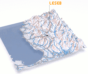 Places with similar names to Leseb, Philippines ::
Disclaimer :: Information on this page comes without warranty of any kind |
||
|
Where is Leseb? Elevation and coordinates ::
Latitude (lat): 16°55'9"N Longitude (lon): 120°53'15"E
Elevation (approx.): 1856m (map arrows pan, magnifying glasses zoom) |
||
|
Visiting Leseb? Hotel/Accommodation ::
Book a hotel in Leseb Travel Guide ::
Buy a travel guide for Philippines rental cars ::
car rental offers GPS waypoint ::
download a GPX waypoint (PoI) of Leseb for your GPS receiver
|
||