|
search place name
|
||
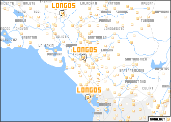
Loñgos (Bulacan, Philippines)Loñgos is a town in the Bulacan region of Philippines. An overview map of the region around Loñgos is displayed below.
regional and 3d topo map of Loñgos, Philippines ::
Loñgos airports ::
The nearest airport is MNL - Manila Ninoy Aquino Intl, located 25.8 km south of Loñgos.
Other airports nearby include BAG - Baguio (185.3 km north), Nearby towns ::
Koloong (0.2km west) //
Liputan (0.6km north west) //
Bayugo (0.9km south) //
Tagalag (1.1km west) //
Katañgalan (1.1km west) //
Bangkal (1.3km south east) //
Bañga (1.5km east) //
Quibadia (1.6km south west) //
Dalandanan (1.7km south east) //
Saluysoy (1.8km north east) //
Mabolo (1.8km south east) //
Meycauayan (2.1km east) //
Malanday (2.2km south east) //
Paco (2.2km west) //
Calvario (2.3km east) //
Nagbalon (2.4km north) //
Polo (2.4km south) //
Bahay Pare (2.6km east) //
Calabingcoho (2.6km east) //
Malajacan (2.8km north east) //
Obando (2.9km south west) //
Hulo (2.8km west) //
Kanumay (3.0km south east) //
Marilao (3.2km north) //
Lawa (3.1km south west) //
Rincon (3.4km south) //
Palasan (3.4km south) //
Balangkas (3.4km south) //
Isla (3.4km south) //
[all distances 'as the bird flies' and approximate]  Places with similar names to Loñgos, Philippines ::
Disclaimer :: Information on this page comes without warranty of any kind |
||
|
Where is Loñgos? Elevation and coordinates ::
Latitude (lat): 14°43'47"N Longitude (lon): 120°56'33"E
Elevation (approx.): 3m (map arrows pan, magnifying glasses zoom) |
||
|
Visiting Loñgos? Hotel/Accommodation ::
Book a hotel in Loñgos Travel Guide ::
Buy a travel guide for Philippines rental cars ::
car rental offers GPS waypoint ::
download a GPX waypoint (PoI) of Loñgos for your GPS receiver
|
||