|
search place name
|
||
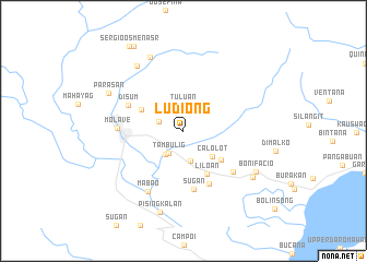
Ludiong (Zamboanga del Sur, Philippines)Ludiong is a town in the Zamboanga del Sur region of Philippines. An overview map of the region around Ludiong is displayed below.
regional and 3d topo map of Ludiong, Philippines ::
Ludiong airports ::
The nearest airport is LGP - Legazpi Pagadian, located 30.6 km south of Ludiong.
Other airports nearby include CGY - Ladag Cagayan De Oro (122.4 km east), CEB - Cebu Cotabato (125.4 km south east), DGT - Dumaguete (140.4 km north), ZAM - Zamboanga Intl (209.0 km south west), Nearby towns ::
Gabunon (2.6km west) //
Tuluan (2.7km north) //
Tambulig (2.7km south west) //
Disum (3.0km south west) //
Balucot (3.2km south) //
Calolot (3.9km south east) //
Dalaon (4.8km north west) //
Panacio (4.8km south east) //
Liloan (5.0km south east) //
Sugan (6.0km south) //
Bulinsong (6.1km south east) //
Disum (6.2km north west) //
Tiaman (6.5km south east) //
Molave (6.7km west) //
Mabao (7.1km south west) //
Parasan (8.1km north west) //
Duntulan (8.3km north west) //
Parasan (8.4km north west) //
Bonifacio (8.4km south east) //
Pisaan (8.5km south east) //
Pisingkalan (8.7km south) //
Gunusan (10.0km north west) //
Sergio Osmeña Sr (10.2km north west) //
[all distances 'as the bird flies' and approximate] 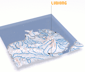 Places with similar names to Ludiong, Philippines ::
Disclaimer :: Information on this page comes without warranty of any kind |
||
|
Where is Ludiong? Elevation and coordinates ::
Latitude (lat): 8°5'19"N Longitude (lon): 123°32'58"E
Elevation (approx.): 174m (map arrows pan, magnifying glasses zoom) |
||
|
Visiting Ludiong? Hotel/Accommodation ::
Book a hotel in Ludiong Travel Guide ::
Buy a travel guide for Philippines rental cars ::
car rental offers GPS waypoint ::
download a GPX waypoint (PoI) of Ludiong for your GPS receiver
|
||