|
search place name
|
||
Mainit (Cebu, Philippines)Mainit is a town in the Cebu region of Philippines. An overview map of the region around Mainit is displayed below.
regional and 3d topo map of Mainit, Philippines ::

Mainit airports ::
The nearest airport is DGT - Dumaguete, located 12.9 km south west of Mainit.
Other airports nearby include NOP - Masbate Mactan Cebu Intl (118.1 km north east), BCD - Bacolod (141.6 km north), ILO - Iloilo (167.1 km north west), CGY - Ladag Cagayan De Oro (178.1 km south east), Nearby towns ::
Liptong (0.9km west) //
Santander (2.7km south west) //
Bunlan (3.2km north west) //
Pasil (3.4km south west) //
Kandamiang (3.4km south west) //
Kabutongan (3.5km north west) //
Looc (4.2km south west) //
Tanawan (4.6km north east) //
Liloan (5.5km west) //
Luka (5.7km north east) //
Calatagan (5.8km north west) //
Talisay (6.0km west) //
Cañang (6.3km north) //
Makapso (6.4km south west) //
Kalasa (6.6km north west) //
Emia (6.8km north west) //
San Sebastian (6.8km north west) //
Cabangcalan (6.9km north) //
Culasi (7.4km north west) //
Alo (7.7km north east) //
Kangtunao (7.7km north) //
Jumangpas (7.7km north) //
Joville (8.5km north west) //
Kanguhinog (8.8km north) //
Dalahikak (8.8km north west) //
Tangbo (10.1km north west) //
Daanglungsod (10.9km north east) //
Sibulan (11.6km south west) //
[all distances 'as the bird flies' and approximate] 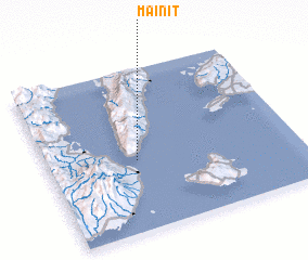 Places with similar names to Mainit, Philippines ::
Disclaimer :: Information on this page comes without warranty of any kind |
||
|
Where is Mainit? Elevation and coordinates ::
Latitude (lat): 9°26'6"N Longitude (lon): 123°21'29"E
Elevation (approx.): 82m (map arrows pan, magnifying glasses zoom) |
||
|
Visiting Mainit? Hotel/Accommodation ::
Book a hotel in Mainit Travel Guide ::
Buy a travel guide for Philippines rental cars ::
car rental offers GPS waypoint ::
download a GPX waypoint (PoI) of Mainit for your GPS receiver
|
||