|
search place name
|
||
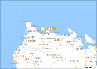
Malatag (Marinduque, Philippines)Malatag is a town in the Marinduque region of Philippines. An overview map of the region around Malatag is displayed below.
regional and 3d topo map of Malatag, Philippines ::
Malatag airports ::
The nearest airport is MNL - Manila Ninoy Aquino Intl, located 147.0 km north west of Malatag.
Other airports nearby include KLO - Kalibo (209.8 km south), Nearby towns ::
Botilao (1.0km north) //
Sayao (2.1km west) //
Datingbayan (2.8km south east) //
Tarug (2.9km south) //
Lamesa (3.2km east) //
Punong (3.4km south west) //
Santikin (3.5km south west) //
Paye (3.9km west) //
Dolores (4.6km south east) //
Mangamnan (5.2km south west) //
Ipil (5.6km east) //
Butansapa (5.7km south) //
Aturan (5.8km south east) //
Guisian (5.9km north west) //
Lamesa (6.0km south east) //
Banto (6.1km south west) //
Bocboc (6.4km south) //
Ino (6.3km west) //
Mesang Bato (6.8km south) //
Bintacay (7.0km south west) //
Lusoc (7.1km east) //
Baliis (7.1km east) //
Balanacan (7.1km west) //
Mangyan-Mababad (7.4km south west) //
Magapua (7.8km south west) //
Argao (7.9km west) //
Landy (8.4km south east) //
Mampaitan (8.7km south west) //
Panghinan (8.7km south west) //
[all distances 'as the bird flies' and approximate]  Places with similar names to Malatag, Philippines ::
Disclaimer :: Information on this page comes without warranty of any kind |
||
|
Where is Malatag? Elevation and coordinates ::
Latitude (lat): 13°31'34"N Longitude (lon): 121°56'7"E
Elevation (approx.): 180m (map arrows pan, magnifying glasses zoom) |
||
|
Visiting Malatag? Hotel/Accommodation ::
Book a hotel in Malatag Travel Guide ::
Buy a travel guide for Philippines rental cars ::
car rental offers GPS waypoint ::
download a GPX waypoint (PoI) of Malatag for your GPS receiver
|
||