|
search place name
|
||
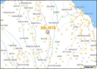
Malinta (Cavite, Philippines)Malinta is a town in the Cavite region of Philippines. An overview map of the region around Malinta is displayed below.
regional and 3d topo map of Malinta, Philippines ::
Malinta airports ::
The nearest airport is MNL - Manila Ninoy Aquino Intl, located 27.4 km north of Malinta.
Nearby towns ::
Embarcadero (1.5km north) //
Biga (1.8km south) //
Bukal (2.3km north) //
Sabutan (2.9km south) //
Biluso (3.1km south west) //
Sampaloc (3.1km north west) //
Silang (3.9km south) //
Paliparan (4.0km north east) //
Palapala (4.1km north) //
Bancal (4.1km north east) //
Bulihan (4.2km north east) //
Ida (5.1km south) //
Bangkal (5.0km east) //
Cedo (5.3km south east) //
Mabatang (5.6km north west) //
Cilibin (5.7km west) //
Javalera (5.8km west) //
Mandaluyong (5.9km west) //
Mutingilog (6.1km south east) //
Luksuhin (6.3km south) //
Carmen (6.3km south east) //
San Agustin (6.3km north west) //
Pasong Bayog (6.8km north) //
Andingan (6.7km west) //
Manggahan (6.8km north west) //
Langkaan (7.0km north west) //
Calubcob (7.1km south) //
Maguyam (7.0km east) //
Pook (7.3km south) //
[all distances 'as the bird flies' and approximate] 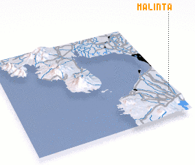 Places with similar names to Malinta, Philippines ::
Disclaimer :: Information on this page comes without warranty of any kind |
||
|
Where is Malinta? Elevation and coordinates ::
Latitude (lat): 14°15'56"N Longitude (lon): 120°58'14"E
Elevation (approx.): 224m (map arrows pan, magnifying glasses zoom) |
||
|
Visiting Malinta? Hotel/Accommodation ::
Book a hotel in Malinta Travel Guide ::
Buy a travel guide for Philippines rental cars ::
car rental offers GPS waypoint ::
download a GPX waypoint (PoI) of Malinta for your GPS receiver
|
||