|
search place name
|
||
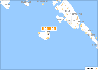
Manban (Eastern Samar, Philippines)Manban is a town in the Eastern Samar region of Philippines. An overview map of the region around Manban is displayed below.
regional and 3d topo map of Manban, Philippines ::
Manban airports ::
The nearest airport is TAC - Tacloban Daniel Z Romualdez, located 73.1 km west of Manban.
Other airports nearby include NOP - Masbate Mactan Cebu Intl (198.3 km west), Nearby towns ::
Buenavista (0.8km north west) //
Manicani (0.8km north) //
Napamulos (1.3km south) //
Banaag (1.6km south west) //
Bacjao (3.9km west) //
Caantulan (4.1km west) //
Tubabao (6.4km north east) //
Lopoc (8.7km north east) //
Guiuan (8.9km north east) //
Mayana (9.1km north east) //
Aliñgarog (9.3km north east) //
Taytay (9.7km north east) //
San Roque (9.7km north east) //
Sung-an (9.7km north east) //
Cantajay (9.7km north east) //
Cabcao (9.7km north east) //
Cagdarao (9.7km north east) //
Timala (10.6km north east) //
[all distances 'as the bird flies' and approximate] 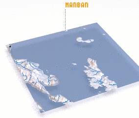 Places with similar names to Manban, Philippines ::
// Manbin (MM)
// Manbin (MM)
// Monbin (MM)
// Monbin (MM)
// Monbin (MM)
// Mônbin (MM)
// Munbin (MM)
// Manabuan (PH)
// Manaybanay (PH)
// Manaybanay (PH)
Disclaimer :: Information on this page comes without warranty of any kind |
||
|
Where is Manban? Elevation and coordinates ::
Latitude (lat): 10°59'39"N Longitude (lon): 125°39'13"E
Elevation (approx.): 5m (map arrows pan, magnifying glasses zoom) |
||
|
Visiting Manban? Hotel/Accommodation ::
Book a hotel in Manban Travel Guide ::
Buy a travel guide for Philippines rental cars ::
car rental offers GPS waypoint ::
download a GPX waypoint (PoI) of Manban for your GPS receiver
|
||