|
search place name
|
||
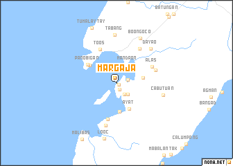
Margaja (Masbate, Philippines)Margaja is a town in the Masbate region of Philippines. An overview map of the region around Margaja is displayed below.
regional and 3d topo map of Margaja, Philippines ::
Margaja airports ::
The nearest airport is KLO - Kalibo, located 112.8 km south west of Margaja.
Other airports nearby include BCD - Bacolod (176.2 km south), ILO - Iloilo (182.3 km south west), SJI - San Jose Antique (215.2 km south west), TAC - Tacloban Daniel Z Romualdez (220.1 km south east), Nearby towns ::
Lantañgan (0.5km south east) //
Bilat (1.2km south) //
Gapos (1.9km east) //
Gabi (2.2km south east) //
Sangig (2.6km south east) //
Mandaon (3.5km north east) //
Lanipian (4.3km east) //
Ayat (4.6km south east) //
Canomoy (4.7km south) //
Guincaiptan (5.1km north west) //
Panobigan (5.4km north west) //
Toos (6.0km north west) //
Manapnap (6.0km south) //
Alas (6.2km north east) //
Tagpu (6.5km east) //
Inintusan (6.6km north east) //
Buri (7.0km south) //
Cabutuan (7.6km east) //
Tabang (7.8km north) //
Dayao (7.8km north east) //
Boong-oco (8.2km north east) //
[all distances 'as the bird flies' and approximate] 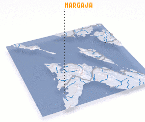 Places with similar names to Margaja, Philippines ::
Disclaimer :: Information on this page comes without warranty of any kind |
||
|
Where is Margaja? Elevation and coordinates ::
Latitude (lat): 12°12'0"N Longitude (lon): 123°16'0"E
Elevation (approx.): -32768m (map arrows pan, magnifying glasses zoom) |
||
|
Visiting Margaja? Hotel/Accommodation ::
Book a hotel in Margaja Travel Guide ::
Buy a travel guide for Philippines rental cars ::
car rental offers GPS waypoint ::
download a GPX waypoint (PoI) of Margaja for your GPS receiver
|
||