|
search place name
|
||
Masaging (Batangas, Philippines)Masaging is a town in the Batangas region of Philippines. An overview map of the region around Masaging is displayed below.
regional and 3d topo map of Masaging, Philippines ::

Masaging airports ::
The nearest airport is MNL - Manila Ninoy Aquino Intl, located 88.3 km north of Masaging.
Nearby towns ::
Malimatok (0.8km south east) //
Saguing (1.0km north east) //
Malimatoc (1.3km south) //
Sili (1.9km north) //
Nagiba (2.0km south) //
Talaga (2.6km north east) //
Santa Monica (3.6km west) //
Panay (3.6km west) //
Bagalañgit (4.0km west) //
Solo (4.1km north west) //
Mainit (4.1km south west) //
Mabini (4.7km north east) //
Anilao (4.8km north) //
Dagatan (5.8km north) //
Magagalin (5.8km north) //
Culut (5.8km north) //
Colvo (6.3km north east) //
Mainaga (6.5km north east) //
Muntingtubig (6.6km north east) //
Talahib (7.0km south) //
Gamao (7.2km south) //
Magalangalang (7.3km north east) //
Recodo (8.2km south west) //
Batogo (8.2km north east) //
Tingloy (8.2km south west) //
Santa Maria (8.9km north east) //
Pinagcruson (8.9km south west) //
Baguilawa (9.5km north east) //
Masasa (9.6km south west) //
[all distances 'as the bird flies' and approximate] 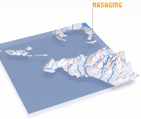
Disclaimer :: Information on this page comes without warranty of any kind |
||
|
Where is Masaging? Elevation and coordinates ::
Latitude (lat): 13°43'0"N Longitude (lon): 120°55'0"E
Elevation (approx.): 100m (map arrows pan, magnifying glasses zoom) |
||
|
Visiting Masaging? Hotel/Accommodation ::
Book a hotel in Masaging Travel Guide ::
Buy a travel guide for Philippines rental cars ::
car rental offers GPS waypoint ::
download a GPX waypoint (PoI) of Masaging for your GPS receiver
|
||