|
search place name
|
||
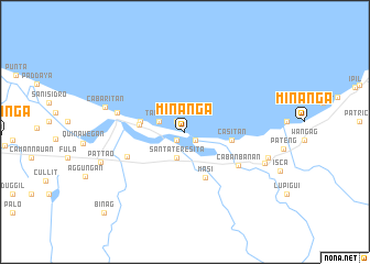
Minanga (Cagayan, Philippines)Minanga is a town in the Cagayan region of Philippines. An overview map of the region around Minanga is displayed below.
regional and 3d topo map of Minanga, Philippines ::
Minanga airports ::
The nearest airport is BAG - Baguio, located 249.8 km south west of Minanga.
Nearby towns ::
Aragao (1.1km south west) //
Mision (1.3km south east) //
Cabittaogan (1.3km north west) //
Santa Teresita (2.8km south) //
Tabboli (2.7km north west) //
Binabbangan (4.4km west) //
Leron (4.4km west) //
Mala (4.5km west) //
Casitan (4.6km east) //
Masi (5.0km south east) //
Maddalero (6.1km south west) //
Cabanbanan (6.2km south east) //
Buguey (6.8km west) //
Cabaritan (8.1km west) //
Nagbabacalan (8.3km east) //
Paddec (8.5km east) //
Pattao (8.7km west) //
Binag (11.3km south west) //
[all distances 'as the bird flies' and approximate] 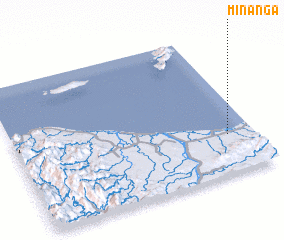 Places with similar names to Minanga, Philippines ::
// Mān Ang (MM)
// Man-aung (MM)
// Manaung (MM)
// Manaung (MM)
// Mān Na-ang (MM)
// Mān Nang (MM)
// Mān Na-ngu (MM)
// Mān Na-ngu (MM)
// Mān Naung (MM)
// Mān Nawng (MM)
Disclaimer :: Information on this page comes without warranty of any kind |
||
|
Where is Minanga? Elevation and coordinates ::
Latitude (lat): 18°16'26"N Longitude (lon): 121°53'26"E
Elevation (approx.): -32768m (map arrows pan, magnifying glasses zoom) |
||
|
Visiting Minanga? Hotel/Accommodation ::
Book a hotel in Minanga Travel Guide ::
Buy a travel guide for Philippines rental cars ::
car rental offers GPS waypoint ::
download a GPX waypoint (PoI) of Minanga for your GPS receiver
|
||