|
search place name
|
||
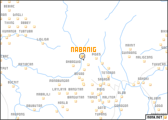
Nabanig (Mountain, Philippines)Nabanig is a town in the Mountain region of Philippines. An overview map of the region around Nabanig is displayed below.
regional and 3d topo map of Nabanig, Philippines ::
Nabanig airports ::
The nearest airport is BAG - Baguio, located 87.9 km south of Nabanig.
Nearby towns ::
Sabean (1.4km south east) //
Agawa (2.1km south) //
Ambaguio (2.6km south west) //
Pides (2.7km east) //
Fidelisan (3.9km east) //
Besao (4.1km south) //
Payeo (4.5km south) //
Padangaan (5.3km south) //
Suquib (5.6km south) //
Tanulon (5.6km east) //
Dalican (5.6km east) //
Besao West (5.8km south) //
Tetepan (6.4km south east) //
Limbasin (6.6km south east) //
Tanolon (6.6km south east) //
Sagada (6.7km south east) //
Nacagan (7.6km south) //
Bangitan (7.6km south) //
Antadao (7.7km south east) //
Panabungan (7.7km south west) //
Pidig (8.2km south east) //
Catengan (8.2km south west) //
Balugan (8.4km south) //
Laylaya (9.1km south west) //
Alab (11.5km south east) //
[all distances 'as the bird flies' and approximate] 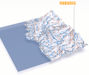 Places with similar names to Nabanig, Philippines ::
Disclaimer :: Information on this page comes without warranty of any kind |
||
|
Where is Nabanig? Elevation and coordinates ::
Latitude (lat): 17°8'0"N Longitude (lon): 120°52'0"E
Elevation (approx.): 1524m (map arrows pan, magnifying glasses zoom) |
||
|
Visiting Nabanig? Hotel/Accommodation ::
Book a hotel in Nabanig Travel Guide ::
Buy a travel guide for Philippines rental cars ::
car rental offers GPS waypoint ::
download a GPX waypoint (PoI) of Nabanig for your GPS receiver
|
||