|
search place name
|
||
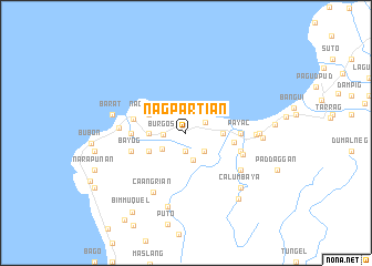
Nagpartian (Ilocos Norte, Philippines)Nagpartian is a town in the Ilocos Norte region of Philippines. An overview map of the region around Nagpartian is displayed below.
regional and 3d topo map of Nagpartian, Philippines ::
Nearby towns ::
Nalituck (1.9km south) //
Suyo (2.2km north east) //
Burgos (2.2km west) //
Dungondungon (2.6km south east) //
Tanap (2.9km south) //
Balbalayan (2.8km south west) //
Otol (3.5km east) //
Pinpinas (3.5km west) //
Cabulalaan (4.0km north west) //
Nagsurot (4.0km north west) //
Bilot (4.0km south west) //
Buduan (4.0km south west) //
Baruyen (4.7km east) //
Buraan (5.2km west) //
Coran (5.3km west) //
Nabang (5.3km west) //
Derrap (5.3km west) //
Payac (5.3km east) //
Bayog (5.6km west) //
Dayas (5.6km east) //
Lipsoc (5.6km east) //
Alaoao (5.8km east) //
Nagubugan (6.4km south east) //
Baral (6.4km west) //
Caangrian (6.7km south west) //
Bonbon (6.7km east) //
Danao (7.0km east) //
Barat (7.3km west) //
Agaga (7.6km south) //
[all distances 'as the bird flies' and approximate] 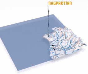 Places with similar names to Nagpartian, Philippines :: Disclaimer :: Information on this page comes without warranty of any kind |
||
|
Where is Nagpartian? Elevation and coordinates ::
Latitude (lat): 18°31'0"N Longitude (lon): 120°40'0"E
Elevation (approx.): 80m (map arrows pan, magnifying glasses zoom) |
||
|
Visiting Nagpartian? Hotel/Accommodation ::
Book a hotel in Nagpartian Travel Guide ::
Buy a travel guide for Philippines rental cars ::
car rental offers GPS waypoint ::
download a GPX waypoint (PoI) of Nagpartian for your GPS receiver
|
||