|
search place name
|
||
Namuco (Batangas, Philippines)Namuco is a town in the Batangas region of Philippines. An overview map of the region around Namuco is displayed below.
regional and 3d topo map of Namuco, Philippines ::

Namuco airports ::
The nearest airport is MNL - Manila Ninoy Aquino Intl, located 77.2 km north of Namuco.
Nearby towns ::
Rosario (1.4km north) //
Itlogan (1.4km south east) //
Bagongpook (1.6km west) //
Lumang Bayan (1.9km north) //
Namuñga (1.9km north) //
Coloñgan (1.9km north) //
Banaybanay (1.9km north) //
Kilib (1.9km north) //
San Ignacio (2.1km west) //
Culungan (2.6km south west) //
Timbugan (2.6km south west) //
Santo Niño (2.6km north east) //
Bayongpooc (2.6km north east) //
Maalas-as (2.6km south east) //
Mabayabas (3.3km south) //
San Roque (3.7km north) //
San Miguel (3.7km north) //
San Agustin (3.9km west) //
Taysan (4.0km south) //
Pinagacañuran (4.1km north west) //
Bacao (4.1km south west) //
Munting-Tubig (4.0km north west) //
Muntingtubig (4.0km north west) //
Quilo-quilo (4.2km north east) //
Mabalor (4.4km south east) //
Balete (4.7km north) //
San Carlos (4.6km east) //
Matala (4.9km west) //
Tilambo (5.1km south east) //
[all distances 'as the bird flies' and approximate] 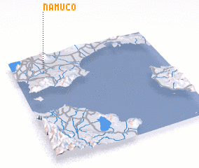 Places with similar names to Namuco, Philippines ::
Disclaimer :: Information on this page comes without warranty of any kind |
||
|
Where is Namuco? Elevation and coordinates ::
Latitude (lat): 13°50'0"N Longitude (lon): 121°12'0"E
Elevation (approx.): 133m (map arrows pan, magnifying glasses zoom) |
||
|
Visiting Namuco? Hotel/Accommodation ::
Book a hotel in Namuco Travel Guide ::
Buy a travel guide for Philippines rental cars ::
car rental offers GPS waypoint ::
download a GPX waypoint (PoI) of Namuco for your GPS receiver
|
||