|
search place name
|
||
Navalas (Iloilo, Philippines)Navalas is a town in the Iloilo region of Philippines. An overview map of the region around Navalas is displayed below.
regional and 3d topo map of Navalas, Philippines ::

Navalas airports ::
The nearest airport is ILO - Iloilo, located 15.3 km west of Navalas.
Other airports nearby include BCD - Bacolod (28.7 km east), SJI - San Jose Antique (82.2 km west), KLO - Kalibo (109.8 km north), NOP - Masbate Mactan Cebu Intl (149.5 km east), Nearby towns ::
San Miguel (0.9km north west) //
Bacjao (1.8km east) //
Getulio (2.3km west) //
Tagob (2.6km north west) //
Loson (2.6km south east) //
Cansilayan (2.9km south) //
Tacay (3.3km west) //
Taminla (3.7km west) //
Supang (3.9km south) //
Tanag (4.1km south east) //
Quinobcoban (4.1km north west) //
Doldol (4.1km north west) //
Banban (4.6km south west) //
Umilig (4.6km south east) //
Avila (5.4km south east) //
San Pedro (5.7km west) //
Tastasan (6.0km south) //
Nazaret (6.1km south) //
San Roque (6.5km south west) //
Zaldivar (6.8km south west) //
Buenavista (7.2km south west) //
Baras (7.5km north) //
Sulangan (7.6km north) //
Sawang (7.6km west) //
Cauong (7.6km west) //
Dacutan (8.0km north) //
San Fernando (7.9km south west) //
Rizal (7.9km south west) //
San Nicolas (7.9km south west) //
[all distances 'as the bird flies' and approximate] 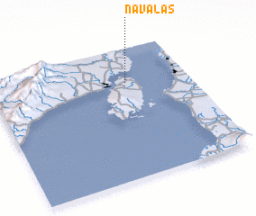 Places with similar names to Navalas, Philippines ::
Disclaimer :: Information on this page comes without warranty of any kind |
||
|
Where is Navalas? Elevation and coordinates ::
Latitude (lat): 10°44'3"N Longitude (lon): 122°41'2"E
Elevation (approx.): 6m (map arrows pan, magnifying glasses zoom) |
||
|
Visiting Navalas? Hotel/Accommodation ::
Book a hotel in Navalas Travel Guide ::
Buy a travel guide for Philippines rental cars ::
car rental offers GPS waypoint ::
download a GPX waypoint (PoI) of Navalas for your GPS receiver
|
||