|
search place name
|
||
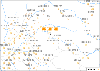
Paganao (Abra, Philippines)Paganao is a town in the Abra region of Philippines. An overview map of the region around Paganao is displayed below.
regional and 3d topo map of Paganao, Philippines ::
Paganao airports ::
The nearest airport is BAG - Baguio, located 145.1 km south of Paganao.
Nearby towns ::
Supiil (0.9km north west) //
Bacooc (1.2km south west) //
Nagtipulan (3.2km south east) //
Cayapa (3.2km east) //
Abualan (4.5km north west) //
Coliong (4.8km north west) //
Culiong (4.8km north west) //
Lam-ag (5.6km west) //
Colabaoan (5.9km west) //
Badas (5.9km west) //
Alimosgan (5.9km west) //
Pattaoig (5.9km west) //
Baug (5.9km west) //
Guimba (5.9km west) //
Lomobang (5.9km west) //
San Juan (6.0km west) //
Ba-y (6.4km north) //
Malaki (6.3km south west) //
Balais (6.3km south west) //
Silet (6.4km north west) //
Nangobongan (6.3km west) //
Alogtog (6.6km south west) //
Lublubba (6.5km south west) //
Daoidao (6.7km west) //
Lenneng (7.2km south east) //
Lupa (7.3km north west) //
Cabcaborao (7.3km north west) //
Bai (7.9km north west) //
Gaang (7.6km west) //
[all distances 'as the bird flies' and approximate]  Places with similar names to Paganao, Philippines ::
Disclaimer :: Information on this page comes without warranty of any kind |
||
|
Where is Paganao? Elevation and coordinates ::
Latitude (lat): 17°40'35"N Longitude (lon): 120°47'18"E
Elevation (approx.): 129m (map arrows pan, magnifying glasses zoom) |
||
|
Visiting Paganao? Hotel/Accommodation ::
Book a hotel in Paganao Travel Guide ::
Buy a travel guide for Philippines rental cars ::
car rental offers GPS waypoint ::
download a GPX waypoint (PoI) of Paganao for your GPS receiver
|
||