|
search place name
|
||
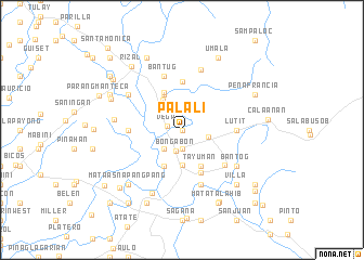
Palali (Nueva Ecija, Philippines)Palali is a town in the Nueva Ecija region of Philippines. An overview map of the region around Palali is displayed below.
regional and 3d topo map of Palali, Philippines ::
Palali airports ::
The nearest airport is BAG - Baguio, located 98.3 km north west of Palali.
Other airports nearby include MNL - Manila Ninoy Aquino Intl (127.1 km south), Nearby towns ::
Tugatog (0.0km north) //
San Pablo (0.0km north) //
Vega (1.6km west) //
Bantug-Villa (1.9km south) //
Bongabon (2.2km south) //
Balacat (2.6km south west) //
Macabaclay (2.7km east) //
Malapajo (3.5km south) //
Macapsing (3.7km north west) //
Tayuman (4.1km south east) //
Bantug (4.1km north west) //
Lusok (4.1km south west) //
San Esteban (4.3km north west) //
Santor (4.7km south) //
Canaan West (5.0km north) //
Lutit (5.4km east) //
Tablang (5.4km west) //
Coronel (5.4km west) //
Antipolo (5.5km south east) //
Pinagbayanan (5.8km south) //
Bantug (5.8km north) //
Canaan East (6.5km north) //
Bantog (6.5km south east) //
Cabucbucan (6.5km north west) //
Paco Roman (6.8km west) //
Sapang Buho (7.1km south west) //
Villa (7.7km south east) //
Balaring (7.7km south west) //
Mataas na Pangpang (7.7km south west) //
[all distances 'as the bird flies' and approximate]  Places with similar names to Palali, Philippines ::
Disclaimer :: Information on this page comes without warranty of any kind |
||
|
Where is Palali? Elevation and coordinates ::
Latitude (lat): 15°39'0"N Longitude (lon): 121°9'0"E
Elevation (approx.): 78m (map arrows pan, magnifying glasses zoom) |
||
|
Visiting Palali? Hotel/Accommodation ::
Book a hotel in Palali Travel Guide ::
Buy a travel guide for Philippines rental cars ::
car rental offers GPS waypoint ::
download a GPX waypoint (PoI) of Palali for your GPS receiver
|
||