|
search place name
|
||
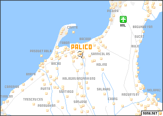
Palico (Cavite, Philippines)Palico is a town in the Cavite region of Philippines. An overview map of the region around Palico is displayed below.
regional and 3d topo map of Palico, Philippines ::
Palico airports ::
The nearest airport is MNL - Manila Ninoy Aquino Intl, located 12.9 km north east of Palico.
Other airports nearby include BAG - Baguio (218.0 km north), Nearby towns ::
Imus (0.4km east) //
Medicion Primero (0.6km north) //
Carsadang Bago (1.0km west) //
Toclong Primero (1.1km north west) //
Bayan Luma (1.4km south) //
Salinas (1.5km north) //
Tinabunan (1.6km west) //
Alapan Segundo (1.7km west) //
Paltoc (1.9km east) //
Alapan Primero (2.0km west) //
Mabolo (2.2km north) //
Gahak (2.4km north west) //
Medicion (2.5km north west) //
Tansang Luma (2.6km east) //
Habay (2.7km north east) //
Toclong Segundo (2.7km north west) //
Binakayan (2.8km north) //
Marulas (2.9km north west) //
Banalo (3.0km north west) //
Mambog (2.9km east) //
Bucan-Dala (3.0km south) //
Panapaan (3.3km north east) //
Pedro Espiritu (3.3km north east) //
Bacoor (3.4km north) //
Alima (3.4km north) //
Kawit (3.6km north west) //
Lamitan (3.6km west) //
Anabu Primero (3.7km south) //
Niog (4.1km north east) //
[all distances 'as the bird flies' and approximate]  Places with similar names to Palico, Philippines ::
Disclaimer :: Information on this page comes without warranty of any kind |
||
|
Where is Palico? Elevation and coordinates ::
Latitude (lat): 14°25'42"N Longitude (lon): 120°55'59"E
Elevation (approx.): 14m (map arrows pan, magnifying glasses zoom) |
||
|
Visiting Palico? Hotel/Accommodation ::
Book a hotel in Palico Travel Guide ::
Buy a travel guide for Philippines rental cars ::
car rental offers GPS waypoint ::
download a GPX waypoint (PoI) of Palico for your GPS receiver
|
||