|
search place name
|
||
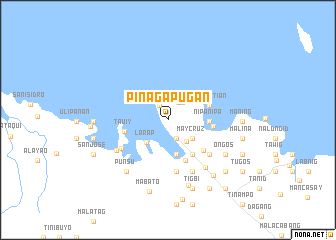
Pinagapugan (Camarines Norte, Philippines)Pinagapugan is a town in the Camarines Norte region of Philippines. An overview map of the region around Pinagapugan is displayed below.
regional and 3d topo map of Pinagapugan, Philippines ::
Pinagapugan airports ::
The nearest airport is MNL - Manila Ninoy Aquino Intl, located 179.8 km west of Pinagapugan.
Nearby towns ::
Pitisan (1.9km north west) //
Fabrica (2.2km south east) //
Kalibigaho (2.2km north east) //
Jose Panganiban (3.1km south east) //
May Cruz (3.4km south east) //
Larap (3.4km south west) //
Dogo (4.0km south) //
Nipanipa (4.5km east) //
Bulwagon (4.5km east) //
Nakalaya (4.7km south east) //
De Leon (4.7km south east) //
Luklukan (4.8km east) //
Pinglintian (4.8km east) //
Panang (4.9km south east) //
Tauiy (4.9km west) //
Gumaus (5.0km east) //
Santa Rosa Norte (5.1km south east) //
Manlutay (5.8km south) //
Nipanipa (5.8km south) //
Pinagilawan (5.9km south east) //
Salvacion (6.0km south west) //
Tinago (6.3km south east) //
Tumbaga (6.3km south east) //
Iba (6.3km south east) //
Barbo (6.6km south east) //
Dahikan (6.6km south west) //
Punsu (7.3km south west) //
Oñgos (7.4km south east) //
Santa Elena (7.6km south) //
[all distances 'as the bird flies' and approximate]  Places with similar names to Pinagapugan, Philippines ::
// Pinagpoocan (PH)
Disclaimer :: Information on this page comes without warranty of any kind |
||
|
Where is Pinagapugan? Elevation and coordinates ::
Latitude (lat): 14°19'6"N Longitude (lon): 122°40'31"E
Elevation (approx.): 37m (map arrows pan, magnifying glasses zoom) |
||
|
Visiting Pinagapugan? Hotel/Accommodation ::
Book a hotel in Pinagapugan Travel Guide ::
Buy a travel guide for Philippines rental cars ::
car rental offers GPS waypoint ::
download a GPX waypoint (PoI) of Pinagapugan for your GPS receiver
|
||