|
search place name
|
||
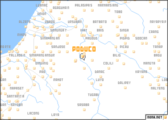
Poduco (Ilocos Sur, Philippines)Poduco is a town in the Ilocos Sur region of Philippines. An overview map of the region around Poduco is displayed below.
regional and 3d topo map of Poduco, Philippines ::
Poduco airports ::
The nearest airport is BAG - Baguio, located 51.9 km south of Poduco.
Nearby towns ::
Sugpon (1.3km north) //
Tubutub (1.8km east) //
Basig (1.9km south) //
Caoayan (1.9km north) //
Pangaotan (1.9km north) //
Matiklico (1.8km west) //
Duplas (1.9km west) //
Pagogo (4.1km north east) //
Old Centro (4.0km north west) //
Danac (5.1km south east) //
Centro (5.1km north west) //
Tubaday (5.4km south) //
Up-uplas (5.5km north) //
Kiat (5.6km north) //
Colili (5.6km east) //
Daddaay (5.8km north) //
Tibunec (5.8km north) //
San Jose (5.6km west) //
Alilem (6.2km north) //
Luyo (6.6km south east) //
Anaao (6.6km north east) //
Bais (6.6km north east) //
San Anastacio (6.6km north west) //
Puto (6.5km west) //
Butubut Norte (7.0km west) //
Bilig (7.1km east) //
San Francisco (7.1km west) //
Dalaoa (7.5km north) //
Amilongan (7.4km north east) //
[all distances 'as the bird flies' and approximate] 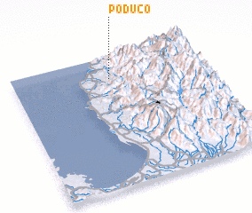 Places with similar names to Poduco, Philippines ::
Disclaimer :: Information on this page comes without warranty of any kind |
||
|
Where is Poduco? Elevation and coordinates ::
Latitude (lat): 16°50'0"N Longitude (lon): 120°31'0"E
Elevation (approx.): 81m (map arrows pan, magnifying glasses zoom) |
||
|
Visiting Poduco? Hotel/Accommodation ::
Book a hotel in Poduco Travel Guide ::
Buy a travel guide for Philippines rental cars ::
car rental offers GPS waypoint ::
download a GPX waypoint (PoI) of Poduco for your GPS receiver
|
||