|
search place name
|
||
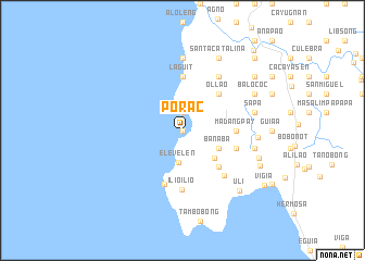
Porac (Pangasinan, Philippines)Porac is a town in the Pangasinan region of Philippines. An overview map of the region around Porac is displayed below.
regional and 3d topo map of Porac, Philippines ::
Porac airports ::
The nearest airport is BAG - Baguio, located 99.5 km north east of Porac.
Other airports nearby include MNL - Manila Ninoy Aquino Intl (214.4 km south east), Nearby towns ::
Baruan (0.0km north) //
Locloc (1.9km north) //
Elevelen (3.3km south) //
Banaba (4.0km south east) //
San Josef (4.0km south east) //
Betogoc (4.2km south east) //
Ollao (5.1km north east) //
Silag (5.1km south east) //
Concordia (5.1km south east) //
Madangpay (5.3km east) //
Laguit (5.6km north) //
Sapa Grande (5.7km east) //
Mabulitec (5.7km east) //
Masangret (5.8km south) //
Ilio-ilio (6.1km south) //
Allabon (6.2km south east) //
Namatucan (6.6km north east) //
Tupa (7.4km north) //
Sapa (7.4km east) //
Sapa Grande (7.4km east) //
Santa Catalina (7.5km east) //
Santa Catalina (8.2km north east) //
Balococ (8.0km north east) //
Arasaas (8.0km north east) //
Laram (8.0km east) //
Uli (8.4km south east) //
Mac Bet (8.5km south east) //
Cabaroan (9.0km north east) //
Vigia (9.8km south east) //
[all distances 'as the bird flies' and approximate]  Places with similar names to Porac, Philippines ::
Disclaimer :: Information on this page comes without warranty of any kind |
||
|
Where is Porac? Elevation and coordinates ::
Latitude (lat): 16°1'0"N Longitude (lon): 119°46'0"E
Elevation (approx.): -32768m (map arrows pan, magnifying glasses zoom) |
||
|
Visiting Porac? Hotel/Accommodation ::
Book a hotel in Porac Travel Guide ::
Buy a travel guide for Philippines rental cars ::
car rental offers GPS waypoint ::
download a GPX waypoint (PoI) of Porac for your GPS receiver
|
||