|
search place name
|
||
Punta Engaño (Lapu-Lapu, Philippines)Punta Engaño is a town in the Lapu-Lapu region of Philippines. An overview map of the region around Punta Engaño is displayed below.
regional and 3d topo map of Punta Engaño, Philippines ::

Punta Engaño airports ::
The nearest airport is NOP - Masbate Mactan Cebu Intl, located 4.2 km west of Punta Engaño.
Other airports nearby include BCD - Bacolod (124.3 km west), DGT - Dumaguete (134.1 km south west), TAC - Tacloban Daniel Z Romualdez (149.6 km north east), ILO - Iloilo (166.9 km west), Nearby towns ::
Buaya (2.5km west) //
Mactan (2.6km south west) //
Maribago (3.5km south west) //
Ibo (3.8km north west) //
Bantolinao (4.1km north west) //
Bankal (4.3km south west) //
Pajak (4.5km south west) //
Pusok (4.4km west) //
Sangi (5.5km west) //
Cogon (5.5km west) //
Agus (5.6km south west) //
Poo (5.9km south) //
Marigondon (5.9km south west) //
Pajo (5.9km west) //
Tingo (6.6km south east) //
Mabini (6.7km south east) //
Opao (6.7km west) //
Gun-ob (6.7km west) //
Santa Rosa (6.8km south east) //
Basbas (6.8km south west) //
Suba (6.9km south west) //
Looc (7.0km west) //
Basak (7.1km south west) //
Suba-Basbas (7.3km west) //
Buagsong (7.3km west) //
Tayud (7.5km north) //
Lapu-Lapu City (7.4km west) //
Cambaro (7.4km west) //
Catarman (7.6km north) //
[all distances 'as the bird flies' and approximate] 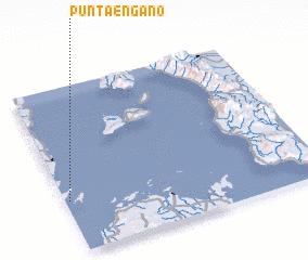 Places with similar names to Punta Engaño, Philippines ::
// P'andŏng-ni (KP)
// Pŏndong-ni (KP)
// Pandŭng-ni (KR)
// Pundungan (ID)
// Pantingan (PH)
// Pindañgan (PH)
// Pindangan (PH)
// Pindungan (PH)
Disclaimer :: Information on this page comes without warranty of any kind |
||
|
Where is Punta Engaño? Elevation and coordinates ::
Latitude (lat): 10°19'0"N Longitude (lon): 124°1'0"E
Elevation (approx.): -32768m (map arrows pan, magnifying glasses zoom) |
||
|
Visiting Punta Engaño? Hotel/Accommodation ::
Book a hotel in Punta Engaño Travel Guide ::
Buy a travel guide for Philippines rental cars ::
car rental offers GPS waypoint ::
download a GPX waypoint (PoI) of Punta Engaño for your GPS receiver
|
||