|
search place name
|
||
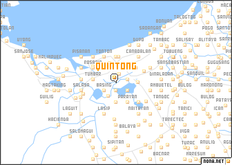
Quintong (Pangasinan, Philippines)Quintong is a town in the Pangasinan region of Philippines. An overview map of the region around Quintong is displayed below.
regional and 3d topo map of Quintong, Philippines ::
Quintong airports ::
The nearest airport is BAG - Baguio, located 56.5 km north east of Quintong.
Other airports nearby include MNL - Manila Ninoy Aquino Intl (183.3 km south east), Nearby towns ::
Dulag (0.5km north) //
Basing (1.3km south) //
Naguelguel (1.4km north) //
Naguilayan (1.8km east) //
Balogo (2.2km south east) //
Basing (2.3km south west) //
Lomboy (2.4km north) //
Nagpalangan (2.4km north) //
Tinculao (2.5km south west) //
Linoc (2.9km north east) //
Manat (2.9km north east) //
Biec (3.0km north west) //
Malawa (3.2km south) //
Malindong (3.3km north) //
Camaley (3.4km east) //
Balagan (3.6km south east) //
Parayan (3.6km south east) //
Tumbar (3.7km west) //
Talogtog (3.7km west) //
Quibaol (3.7km west) //
Linoc (3.9km north east) //
Binmaley (4.2km north) //
Parayao (4.2km north) //
Lupis (4.2km north) //
Dulag (4.2km north) //
Caloocan (4.2km north) //
San Isidro (4.2km north) //
Rosario (4.3km north west) //
Matalaba (4.3km north west) //
[all distances 'as the bird flies' and approximate] 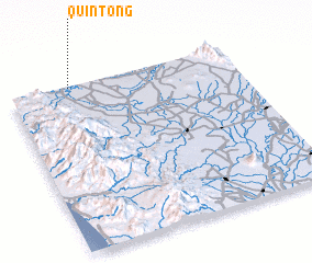 Places with similar names to Quintong, Philippines ::
Disclaimer :: Information on this page comes without warranty of any kind |
||
|
Where is Quintong? Elevation and coordinates ::
Latitude (lat): 15°59'43"N Longitude (lon): 120°16'2"E
Elevation (approx.): 7m (map arrows pan, magnifying glasses zoom) |
||
|
Visiting Quintong? Hotel/Accommodation ::
Book a hotel in Quintong Travel Guide ::
Buy a travel guide for Philippines rental cars ::
car rental offers GPS waypoint ::
download a GPX waypoint (PoI) of Quintong for your GPS receiver
|
||