|
search place name
|
||
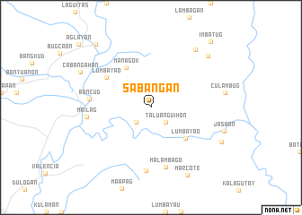
Sabangan (Bukidnon, Philippines)Sabangan is a town in the Bukidnon region of Philippines. An overview map of the region around Sabangan is displayed below.
regional and 3d topo map of Sabangan, Philippines ::
Sabangan airports ::
The nearest airport is CGY - Ladag Cagayan De Oro, located 82.1 km north west of Sabangan.
Other airports nearby include CEB - Cebu Cotabato (143.3 km south west), LGP - Legazpi Pagadian (194.7 km west), DGT - Dumaguete (258.4 km north west), Nearby towns ::
Taluanguihon (2.6km south east) //
Macote (2.6km south west) //
Lumbayao (5.8km south east) //
Managok (5.8km north west) //
Lumbayao (6.6km north west) //
Malambago (7.6km south) //
Bancud (7.6km west) //
Datu-Mamandus (7.9km south) //
Mailag (8.0km west) //
Maglamin (9.0km north east) //
Cabulohan (9.5km north east) //
Marcote (9.6km south east) //
Nasablayan (9.6km south east) //
Cabangahan (9.7km north west) //
Linabo (10.4km north west) //
Imbatug (11.0km north east) //
[all distances 'as the bird flies' and approximate] 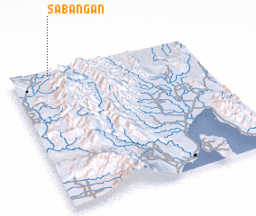 Places with similar names to Sabangan, Philippines ::
// Siebenecken (DE)
// Siebenknie (DE)
// Sebangan (MY)
// Sebangan (MY)
// Żabieniec Nowy (PL)
// Sabangan (ID)
// Sibangun (ID)
// Sibangani (ZM)
// Sobung-ni (KP)
// Subong-ni (KP)
Disclaimer :: Information on this page comes without warranty of any kind |
||
|
Where is Sabangan? Elevation and coordinates ::
Latitude (lat): 7°59'0"N Longitude (lon): 125°13'0"E
Elevation (approx.): 428m (map arrows pan, magnifying glasses zoom) |
||
|
Visiting Sabangan? Hotel/Accommodation ::
Book a hotel in Sabangan Travel Guide ::
Buy a travel guide for Philippines rental cars ::
car rental offers GPS waypoint ::
download a GPX waypoint (PoI) of Sabangan for your GPS receiver
|
||