|
search place name
|
||
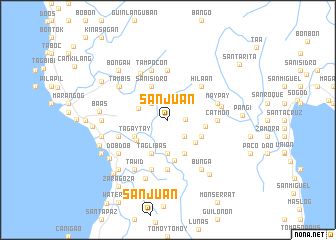
San Juan (Leyte, Philippines)San Juan is a town in the Leyte region of Philippines. An overview map of the region around San Juan is displayed below.
regional and 3d topo map of San Juan, Philippines ::
San Juan airports ::
The nearest airport is NOP - Masbate Mactan Cebu Intl, located 95.6 km west of San Juan.
Other airports nearby include TAC - Tacloban Daniel Z Romualdez (97.2 km north), DGT - Dumaguete (204.8 km south west), BCD - Bacolod (212.4 km west), CGY - Ladag Cagayan De Oro (217.4 km south), Nearby towns ::
Hibaguan (1.9km east) //
Cangiras (2.6km north west) //
Anahawan (2.6km south east) //
Tuguipa (3.5km west) //
Kandoong (3.7km south) //
Tugas (3.9km south east) //
San Isidro (4.1km north west) //
Tagaytay (4.1km south west) //
Naga (4.1km south west) //
Baliw (4.1km south east) //
Taglibas (4.1km south west) //
Songon (4.1km south east) //
Alejos (4.1km south west) //
Hitudpan (4.2km east) //
Mangitngit (4.6km south) //
Hilaan (5.2km north east) //
San Isidro (5.6km south) //
Libjo (5.6km south) //
Kapodlusan (5.6km north) //
Catmon (5.5km east) //
Maypay (5.8km east) //
Pange (5.9km south) //
Tampocon (5.9km north) //
Tabonoc (5.8km west) //
Santa Margarita (6.0km north west) //
Himakilo (6.1km east) //
Tambis (6.5km north west) //
Tawid (6.6km south west) //
Pa-a (6.6km north west) //
[all distances 'as the bird flies' and approximate] 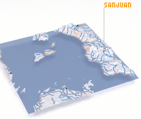 Places with similar names to San Juan, Philippines ::
Disclaimer :: Information on this page comes without warranty of any kind |
||
|
Where is San Juan? Elevation and coordinates ::
Latitude (lat): 10°22'0"N Longitude (lon): 124°51'0"E
Elevation (approx.): 103m (map arrows pan, magnifying glasses zoom) |
||
|
Visiting San Juan? Hotel/Accommodation ::
Book a hotel in San Juan Travel Guide ::
Buy a travel guide for Philippines rental cars ::
car rental offers GPS waypoint ::
download a GPX waypoint (PoI) of San Juan for your GPS receiver
|
||