|
search place name
|
||
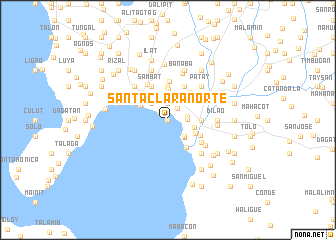
Santa Clara Norte (Batangas, Philippines)Santa Clara Norte is a town in the Batangas region of Philippines. An overview map of the region around Santa Clara Norte is displayed below.
regional and 3d topo map of Santa Clara Norte, Philippines ::
Santa Clara Norte airports ::
The nearest airport is MNL - Manila Ninoy Aquino Intl, located 82.1 km north of Santa Clara Norte.
Nearby towns ::
Santa Clara Sur (0.0km north) //
Aplaya (1.2km north west) //
Santa Rita (1.6km north east) //
Santa Rita Calzada (1.9km north) //
Calicanto (2.2km east) //
Bolboc (2.2km east) //
San Antonio (2.6km north west) //
Dalig (2.6km south east) //
Cueva (2.6km south east) //
Alañgilan (2.6km south east) //
Sambat (2.6km south east) //
Lagnas (2.7km north) //
Batangas (3.0km east) //
Santa Clara (3.3km south east) //
San Pascual (3.4km north) //
Cota (3.4km north west) //
Wawa (3.7km south east) //
Banaba Bauan (3.7km north) //
Cumba (3.6km east) //
Camp McGrath (3.6km east) //
Calansayan (3.6km east) //
Pallocan (3.9km south east) //
Tinga Itaas (4.0km north east) //
Gulibay (4.0km north west) //
Gelerangcawayan (4.0km north west) //
Danglayan (4.0km north west) //
Dominador (4.0km north west) //
Malindig (4.0km north west) //
Sambat (4.1km north west) //
[all distances 'as the bird flies' and approximate]  Places with similar names to Santa Clara Norte, Philippines :: Disclaimer :: Information on this page comes without warranty of any kind |
||
|
Where is Santa Clara Norte? Elevation and coordinates ::
Latitude (lat): 13°46'0"N Longitude (lon): 121°2'0"E
Elevation (approx.): 2m (map arrows pan, magnifying glasses zoom) |
||
|
Visiting Santa Clara Norte? Hotel/Accommodation ::
Book a hotel in Santa Clara Norte Travel Guide ::
Buy a travel guide for Philippines rental cars ::
car rental offers GPS waypoint ::
download a GPX waypoint (PoI) of Santa Clara Norte for your GPS receiver
|
||