|
search place name
|
||
Santa Cruz (Cagayan, Philippines)Santa Cruz is a town in the Cagayan region of Philippines. An overview map of the region around Santa Cruz is displayed below.
regional and 3d topo map of Santa Cruz, Philippines ::
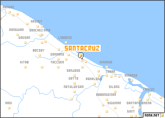
Nearby towns ::
Bidduang (0.3km south) //
Allassitan (0.9km south east) //
Casitan (1.9km south) //
Pilig (3.2km west) //
Balinguit (3.5km west) //
San Jose (4.1km south west) //
Birucang (4.4km south east) //
San Juan (5.1km south east) //
Labbeng (5.1km north west) //
Gammaro (5.3km west) //
Bangan (5.6km west) //
Taccuen (5.6km west) //
Cabbaggan (5.6km east) //
Minanga (5.6km east) //
Gatto (5.8km south) //
Dagao (5.8km south) //
Pamplona (6.2km south east) //
Allappangan (6.4km south east) //
Natulungan (7.6km south) //
Tabba (7.4km south east) //
Fugue (7.9km south east) //
Annabatan (8.9km south east) //
Langangan (9.0km north west) //
Silong (10.2km south east) //
[all distances 'as the bird flies' and approximate] 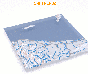 Places with similar names to Santa Cruz, Philippines ::
// Santa Cruz (BR)
// Santa Cruz (BR)
// Santa Cruz (BR)
// Santa Cruz (BR)
// Santa Cruz (BR)
// Santa Cruz (BR)
// Santa Cruz (BR)
// Santa Cruz (BR)
// Santa Cruz (BR)
// Santa Cruz (BR)
Disclaimer :: Information on this page comes without warranty of any kind |
||
|
Where is Santa Cruz? Elevation and coordinates ::
Latitude (lat): 18°31'0"N Longitude (lon): 121°19'0"E
Elevation (approx.): 7m (map arrows pan, magnifying glasses zoom) |
||
|
Visiting Santa Cruz? Hotel/Accommodation ::
Book a hotel in Santa Cruz Travel Guide ::
Buy a travel guide for Philippines rental cars ::
car rental offers GPS waypoint ::
download a GPX waypoint (PoI) of Santa Cruz for your GPS receiver
|
||