|
search place name
|
||
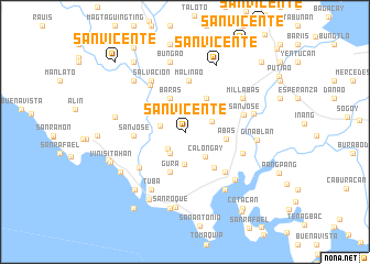
San Vicente (Sorsogon, Philippines)San Vicente is a town in the Sorsogon region of Philippines. An overview map of the region around San Vicente is displayed below.
regional and 3d topo map of San Vicente, Philippines ::
San Vicente airports ::
The nearest airport is KLO - Kalibo, located 197.4 km south west of San Vicente.
Other airports nearby include TAC - Tacloban Daniel Z Romualdez (245.5 km south east), Nearby towns ::
Catamlangan (2.3km north) //
Bayawas (2.4km south west) //
Mabini (2.5km west) //
Maguisa (2.6km south west) //
Abucay (2.9km east) //
Calongay (3.2km south east) //
Sevilla (3.3km south) //
Migabod (3.6km north east) //
Baras (3.7km north west) //
Catamlagan (4.0km north east) //
Abas (4.2km east) //
Gura (4.3km south) //
Santa Fé (4.7km south east) //
San Jose (5.1km west) //
Malinao (5.2km north) //
Poctol (5.7km south east) //
Calpe (5.7km south east) //
Pineda (5.7km south east) //
Pinagsalog (5.7km south east) //
Bual (5.7km south east) //
Palanas (5.7km south east) //
Banuang Gurang (5.8km north west) //
Malaya (5.8km south west) //
Salvacion (6.2km north west) //
Maharoan (6.2km north west) //
San José (6.1km east) //
Mabanate (6.2km east) //
Millabas (6.7km north east) //
Parina (6.8km south west) //
[all distances 'as the bird flies' and approximate] 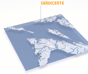 Places with similar names to San Vicente, Philippines ::
// San Vicente (US)
// San Vicente (PA)
// San Vicente (PA)
// San Vicente (CU)
// San Vicente (CU)
// San Vicente (CU)
// San Vicente (CU)
// San Vicente (CU)
// San Vicente (CU)
// San Vicente (CU)
Disclaimer :: Information on this page comes without warranty of any kind |
||
|
Where is San Vicente? Elevation and coordinates ::
Latitude (lat): 12°58'11"N Longitude (lon): 123°37'49"E
Elevation (approx.): 18m (map arrows pan, magnifying glasses zoom) |
||
|
Visiting San Vicente? Hotel/Accommodation ::
Book a hotel in San Vicente Travel Guide ::
Buy a travel guide for Philippines rental cars ::
car rental offers GPS waypoint ::
download a GPX waypoint (PoI) of San Vicente for your GPS receiver
|
||