|
search place name
|
||
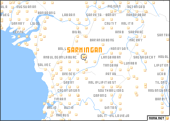
Sarmingan (Ilocos Sur, Philippines)Sarmingan is a town in the Ilocos Sur region of Philippines. An overview map of the region around Sarmingan is displayed below.
regional and 3d topo map of Sarmingan, Philippines ::
Sarmingan airports ::
The nearest airport is BAG - Baguio, located 121.4 km south of Sarmingan.
Nearby towns ::
Codoog (0.3km south east) //
Marozo (1.1km north) //
Tupac-Estancia (1.6km west) //
Balaweg (2.0km south) //
Bantugo (2.0km south) //
Taleb (2.0km south) //
Lapting (2.0km south) //
Casilagan (2.0km east) //
Balasiw (2.3km north west) //
Bal-lasiw see Balasiw (2.3km north west) //
Coboog (2.6km south west) //
Rizal (2.6km south west) //
Nagbukel (2.6km south) //
Banglayan (3.3km west) //
San Pablo (3.9km south) //
Parparia (3.9km south west) //
Mission (4.2km south) //
Cadacad (4.1km north east) //
Tangadon (4.6km north) //
Orence (5.1km south west) //
Barangobong (5.1km north east) //
Ambulogan-Labuac (5.1km west) //
Pantoc (5.4km north) //
Baribarit (5.5km north) //
Ambulogan (5.3km west) //
Vica (5.6km north) //
Tangadan (5.6km north) //
Bidal (5.6km north) //
Aquib (5.5km west) //
[all distances 'as the bird flies' and approximate]  Places with similar names to Sarmingan, Philippines :: Disclaimer :: Information on this page comes without warranty of any kind |
||
|
Where is Sarmingan? Elevation and coordinates ::
Latitude (lat): 17°28'6"N Longitude (lon): 120°31'53"E
Elevation (approx.): 37m (map arrows pan, magnifying glasses zoom) |
||
|
Visiting Sarmingan? Hotel/Accommodation ::
Book a hotel in Sarmingan Travel Guide ::
Buy a travel guide for Philippines rental cars ::
car rental offers GPS waypoint ::
download a GPX waypoint (PoI) of Sarmingan for your GPS receiver
|
||