|
search place name
|
||
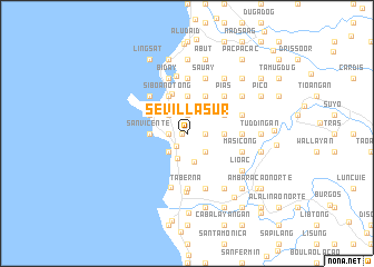
Sevilla Sur (La Union, Philippines)Sevilla Sur is a town in the La Union region of Philippines. An overview map of the region around Sevilla Sur is displayed below.
regional and 3d topo map of Sevilla Sur, Philippines ::
Sevilla Sur airports ::
The nearest airport is BAG - Baguio, located 38.3 km south east of Sevilla Sur.
Nearby towns ::
Sevilla Centro (0.5km west) //
Paringao (1.6km south west) //
Pagdalagan (1.8km west) //
Narra Oeste (1.8km east) //
Bungro (1.8km east) //
Sagayad (1.9km north) //
Paringdor (2.6km south west) //
Pagdalagan (2.6km south west) //
Narra Este (2.6km south east) //
Santiago Sur (2.6km north west) //
Parian (2.6km north west) //
Lossoc (2.7km south) //
Palintocang (3.0km south) //
Langcuas (3.4km north east) //
San Vicente (3.6km west) //
Birunget (3.6km east) //
Santiago Norte (3.7km north) //
Madayegdeg (4.0km north west) //
Canaoay (4.0km north west) //
San Francisco (4.0km north west) //
Saoay (4.1km north west) //
Dal-langayan Este (4.1km north west) //
Dal-langayan Oeste (4.1km north west) //
Catbangen (4.1km north west) //
Ilocanos Sur (4.1km north west) //
Negro (4.1km north west) //
Ilocanos Norte (4.1km north west) //
Namtutan (4.1km north west) //
Bangbangolan (4.1km north west) //
[all distances 'as the bird flies' and approximate] 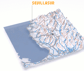 Places with similar names to Sevilla Sur, Philippines :: Disclaimer :: Information on this page comes without warranty of any kind |
||
|
Where is Sevilla Sur? Elevation and coordinates ::
Latitude (lat): 16°35'0"N Longitude (lon): 120°20'0"E
Elevation (approx.): 27m (map arrows pan, magnifying glasses zoom) |
||
|
Visiting Sevilla Sur? Hotel/Accommodation ::
Book a hotel in Sevilla Sur Travel Guide ::
Buy a travel guide for Philippines rental cars ::
car rental offers GPS waypoint ::
download a GPX waypoint (PoI) of Sevilla Sur for your GPS receiver
|
||