|
search place name
|
||
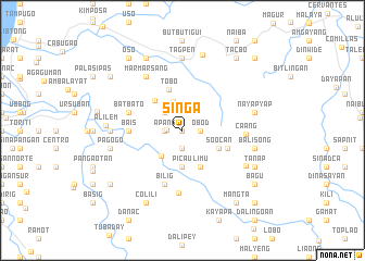
Singa (Ilocos Sur, Philippines)Singa is a town in the Ilocos Sur region of Philippines. An overview map of the region around Singa is displayed below.
regional and 3d topo map of Singa, Philippines ::
Singa airports ::
The nearest airport is BAG - Baguio, located 56.3 km south of Singa.
Nearby towns ::
Pandayan (NaNkm north) //
Liblibo (NaNkm north) //
Apaya (1.5km west) //
Pidpid (1.9km south) //
Apang (1.8km west) //
Obod (1.8km east) //
Laglagan (2.6km north west) //
Tibo (3.0km north) //
Amilongan (3.4km south west) //
Picau (3.7km south) //
Dupay (3.7km south) //
Soocan (4.0km south east) //
Limu (4.1km south east) //
Mamarsang (4.1km north west) //
Tobo (4.3km north) //
Balbalit (4.8km east) //
Bais (5.3km west) //
Anaao (5.3km west) //
Batbato (5.6km west) //
Bilig (5.8km south) //
Tamoroog (6.4km south) //
Caang (6.2km east) //
Marmarsang (6.6km north west) //
Tibunec (7.1km west) //
Butac (7.4km north) //
Daddaay (7.1km west) //
Tagpen (7.4km north) //
Bino (7.3km south east) //
Balisong (7.3km east) //
[all distances 'as the bird flies' and approximate] 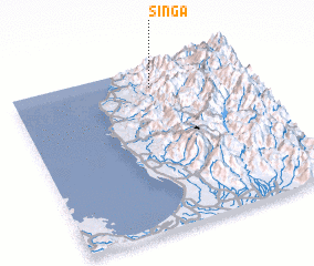 Places with similar names to Singa, Philippines ::
Disclaimer :: Information on this page comes without warranty of any kind |
||
|
Where is Singa? Elevation and coordinates ::
Latitude (lat): 16°53'0"N Longitude (lon): 120°36'0"E
Elevation (approx.): 1150m (map arrows pan, magnifying glasses zoom) |
||
|
Visiting Singa? Hotel/Accommodation ::
Book a hotel in Singa Travel Guide ::
Buy a travel guide for Philippines rental cars ::
car rental offers GPS waypoint ::
download a GPX waypoint (PoI) of Singa for your GPS receiver
|
||