|
search place name
|
||
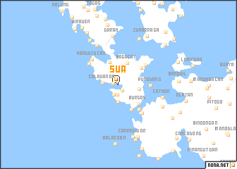
Sua (Samar, Philippines)Sua is a town in the Samar region of Philippines. An overview map of the region around Sua is displayed below.
regional and 3d topo map of Sua, Philippines ::
Sua airports ::
The nearest airport is TAC - Tacloban Daniel Z Romualdez, located 44.9 km south east of Sua.
Other airports nearby include NOP - Masbate Mactan Cebu Intl (166.1 km south west), BCD - Bacolod (229.0 km south west), Nearby towns ::
Candoque (0.8km west) //
Hungan (1.1km south east) //
Cabelisan (1.6km south) //
Mabini (1.8km south) //
Calauan-on (2.5km west) //
Tugas (2.7km south) //
Guintamplan (3.3km east) //
Bagacay (3.7km north) //
Saugan (3.8km north) //
Burgos (4.3km south east) //
Lipundan (4.4km north east) //
Iquiran (4.5km south east) //
Placer (5.0km south east) //
Pungdang (5.0km east) //
Baclayon (5.3km north east) //
Bak-jao (5.6km north west) //
Manduyucan (5.7km north west) //
Talalora (5.9km south east) //
Mayaboy (7.1km north west) //
Catmon (7.1km east) //
Daram (7.6km north) //
Mallorga (7.7km south east) //
Manduyucan (7.9km north east) //
Mungolbungol (7.9km north east) //
Malara (8.3km north west) //
Corregidor (8.7km south) //
Zumarraga (8.8km north east) //
Tatabunan (8.9km south) //
Navatas (9.1km south) //
[all distances 'as the bird flies' and approximate]  Places with similar names to Sua, Philippines ::
Disclaimer :: Information on this page comes without warranty of any kind |
||
|
Where is Sua? Elevation and coordinates ::
Latitude (lat): 11°34'7"N Longitude (lon): 124°48'15"E
Elevation (approx.): 3m (map arrows pan, magnifying glasses zoom) |
||
|
Visiting Sua? Hotel/Accommodation ::
Book a hotel in Sua Travel Guide ::
Buy a travel guide for Philippines rental cars ::
car rental offers GPS waypoint ::
download a GPX waypoint (PoI) of Sua for your GPS receiver
|
||