|
search place name
|
||
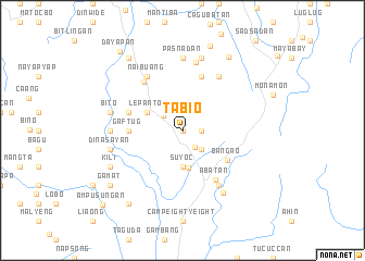
Tabio (Benguet, Philippines)Tabio is a town in the Benguet region of Philippines. An overview map of the region around Tabio is displayed below.
regional and 3d topo map of Tabio, Philippines ::
Tabio airports ::
The nearest airport is BAG - Baguio, located 56.0 km south of Tabio.
Nearby towns ::
Cobang (0.0km north) //
Cabali (1.9km north) //
Suyoc (1.8km east) //
Bulalacao (2.0km south east) //
Mankayan (2.5km north west) //
Colos (2.6km north west) //
Balili (2.6km north east) //
Sapid (2.6km north west) //
Paco (2.6km north west) //
Gubano (2.6km south east) //
Suyoc (3.7km south) //
Palasa-an (3.8km south) //
Lepanto (4.0km north west) //
Bangao (5.3km south east) //
Gaftug (5.3km west) //
Sapnit (5.6km west) //
Bong (5.8km north) //
Bedbed (5.8km north) //
Abatan (5.9km south east) //
Cabitin (6.3km north west) //
Naibuang (6.6km north west) //
Kolalo (6.6km north west) //
Panquican (6.6km north east) //
Baculongan (6.6km south east) //
Dacudac (7.2km north) //
Pasnadan (7.4km north) //
Sinadca (7.1km west) //
Loo (7.4km south east) //
Bito (7.3km west) //
[all distances 'as the bird flies' and approximate] 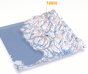 Places with similar names to Tabio, Philippines ::
Disclaimer :: Information on this page comes without warranty of any kind |
||
|
Where is Tabio? Elevation and coordinates ::
Latitude (lat): 16°51'0"N Longitude (lon): 120°48'0"E
Elevation (approx.): 1407m (map arrows pan, magnifying glasses zoom) |
||
|
Visiting Tabio? Hotel/Accommodation ::
Book a hotel in Tabio Travel Guide ::
Buy a travel guide for Philippines rental cars ::
car rental offers GPS waypoint ::
download a GPX waypoint (PoI) of Tabio for your GPS receiver
|
||