|
search place name
|
||
Tadian (Mountain, Philippines)Tadian is a town in the Mountain region of Philippines. An overview map of the region around Tadian is displayed below.
regional and 3d topo map of Tadian, Philippines ::

Tadian airports ::
The nearest airport is BAG - Baguio, located 71.8 km south of Tadian.
Nearby towns ::
Baloa (1.3km south west) //
Kayan (1.4km south west) //
Balaoa (1.9km south) //
Tue (3.1km south) //
Mayag (3.3km south east) //
Lubon (4.1km north) //
Sumadel (4.6km north) //
Paling (5.0km south) //
Masla (5.1km north) //
Cagubatan (5.1km south) //
Bauko (4.9km east) //
Batayan (5.0km east) //
Balintaugan (5.0km east) //
Guinsadan (6.0km south east) //
Pandayan (6.2km south) //
Mantiba (6.3km south west) //
Bila (6.3km east) //
Banao (6.3km east) //
Alulin (6.5km west) //
Banguitan (6.9km north east) //
Banaao (7.3km south) //
Abubutan (7.3km north west) //
Otukan (7.3km east) //
Pilipil (7.6km south west) //
Talebubu (7.6km south west) //
Mabalili (8.0km north west) //
Laylaya (8.1km north) //
Catengan (8.2km north) //
Sadsadan (8.3km south east) //
[all distances 'as the bird flies' and approximate] 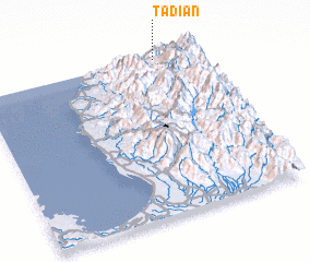 Places with similar names to Tadian, Philippines ::
Disclaimer :: Information on this page comes without warranty of any kind |
||
|
Where is Tadian? Elevation and coordinates ::
Latitude (lat): 16°59'38"N Longitude (lon): 120°49'17"E
Elevation (approx.): 1317m (map arrows pan, magnifying glasses zoom) |
||
|
Visiting Tadian? Hotel/Accommodation ::
Book a hotel in Tadian Travel Guide ::
Buy a travel guide for Philippines rental cars ::
car rental offers GPS waypoint ::
download a GPX waypoint (PoI) of Tadian for your GPS receiver
|
||