|
search place name
|
||
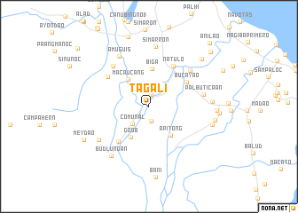
Tagali (Mindoro Oriental, Philippines)Tagali is a town in the Mindoro Oriental region of Philippines. An overview map of the region around Tagali is displayed below.
regional and 3d topo map of Tagali, Philippines ::
Tagali airports ::
The nearest airport is MNL - Manila Ninoy Aquino Intl, located 137.8 km north of Tagali.
Other airports nearby include KLO - Kalibo (220.4 km south east), Nearby towns ::
Goob (1.5km north) //
Inarawan (1.9km south) //
Comunal (2.9km south west) //
Macaucang (4.2km north west) //
Goob (4.5km south west) //
Apitong (4.5km south east) //
Biga (4.8km north) //
Bucayao (5.6km north east) //
Aurora (5.8km south west) //
Natulo (5.9km north east) //
Dulangan (6.3km north west) //
Kalauang (6.7km north west) //
Managpi (6.8km north east) //
Palbuticaan (6.9km east) //
Amuguis (7.3km north west) //
Bacton (7.4km south west) //
Simarron (7.6km north) //
Budlungan (7.7km south west) //
Barcanaga (7.8km east) //
Balanacan (8.1km east) //
Mag-Asawang-Tubig (8.3km east) //
Bolbog (8.3km east) //
Lagonlongan (8.8km north east) //
Garis (8.7km east) //
Mey Dao (9.0km south west) //
Canubing No 2 (9.2km north) //
Magindat (10.2km north east) //
Anilao (11.0km north east) //
[all distances 'as the bird flies' and approximate]  Places with similar names to Tagali, Philippines ::
Disclaimer :: Information on this page comes without warranty of any kind |
||
|
Where is Tagali? Elevation and coordinates ::
Latitude (lat): 13°16'15"N Longitude (lon): 121°9'25"E
Elevation (approx.): 19m (map arrows pan, magnifying glasses zoom) |
||
|
Visiting Tagali? Hotel/Accommodation ::
Book a hotel in Tagali Travel Guide ::
Buy a travel guide for Philippines rental cars ::
car rental offers GPS waypoint ::
download a GPX waypoint (PoI) of Tagali for your GPS receiver
|
||