|
search place name
|
||
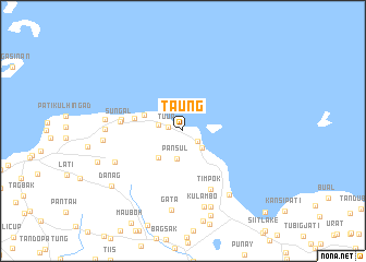
Taung (Sulu, Philippines)Taung is a town in the Sulu region of Philippines. An overview map of the region around Taung is displayed below.
regional and 3d topo map of Taung, Philippines ::
Taung airports ::
The nearest airport is ZAM - Zamboanga Intl, located 138.2 km north east of Taung.
Nearby towns ::
Tuup (1.6km west) //
Payukan (1.8km south east) //
Pangdanon (2.5km west) //
Bonbon (2.6km south east) //
Pansul (2.9km south) //
Panglayahan (3.7km south west) //
Patikul (4.2km west) //
Igasan (5.1km west) //
Sungal (6.4km west) //
Kaunayan (6.4km west) //
Timpok (6.6km south east) //
Kabbon-Takas (7.6km south west) //
Sū (8.0km south east) //
Sanda (8.0km west) //
Kulambo (8.0km south) //
Kadday-Mampallan (8.1km west) //
Gata (8.2km south) //
Bangkal (8.3km west) //
Parang Uba (8.3km west) //
Tandu” Payukan (8.3km west) //
Darayan (8.3km west) //
Gi”tung (8.3km west) //
Kan Agi (8.3km west) //
Kandayok (8.3km south) //
Tiptipon (9.1km south) //
Danag (9.1km south west) //
Maligay (9.3km west) //
Caduayan (11.8km south east) //
[all distances 'as the bird flies' and approximate]  Places with similar names to Taung, Philippines ::
Disclaimer :: Information on this page comes without warranty of any kind |
||
|
Where is Taung? Elevation and coordinates ::
Latitude (lat): 6°4'30"N Longitude (lon): 121°8'27"E
Elevation (approx.): 14m (map arrows pan, magnifying glasses zoom) |
||
|
Visiting Taung? Hotel/Accommodation ::
Book a hotel in Taung Travel Guide ::
Buy a travel guide for Philippines rental cars ::
car rental offers GPS waypoint ::
download a GPX waypoint (PoI) of Taung for your GPS receiver
|
||