|
search place name
|
||
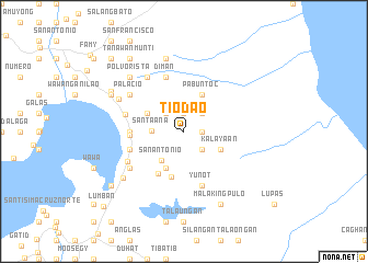
Tiodao (Laguna, Philippines)Tiodao is a town in the Laguna region of Philippines. An overview map of the region around Tiodao is displayed below.
regional and 3d topo map of Tiodao, Philippines ::
Tiodao airports ::
The nearest airport is MNL - Manila Ninoy Aquino Intl, located 57.6 km west of Tiodao.
Nearby towns ::
Tobog (1.9km north) //
Papatahan (1.8km east) //
Tandong (2.6km north west) //
Bangco (2.6km north east) //
Bucboc (2.6km north east) //
Lamao (2.6km south east) //
Santa Ana (3.2km west) //
San Antonio (3.7km south west) //
Serena (4.0km north west) //
Pabuntoc (4.1km north east) //
Malakaban (4.1km south west) //
Kalayaan (4.0km south east) //
Santo Angel (4.8km south) //
Sala (5.0km south west) //
Paete (5.4km west) //
Bagongbayan (5.4km west) //
Diman (5.8km north) //
Ilog Patulo (5.7km west) //
Yunot (5.8km south) //
Magalolong (5.8km south) //
Pakil (6.1km west) //
Loñgos (6.4km south west) //
Binambang (6.6km north west) //
Palacio (6.5km north west) //
Lunao (6.5km south west) //
Balian (7.2km north west) //
Ligawang (7.6km north) //
San Juan (7.6km south west) //
Inaraduhan (7.7km north west) //
[all distances 'as the bird flies' and approximate] 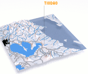 Places with similar names to Tiodao, Philippines ::
Disclaimer :: Information on this page comes without warranty of any kind |
||
|
Where is Tiodao? Elevation and coordinates ::
Latitude (lat): 14°22'0"N Longitude (lon): 121°32'0"E
Elevation (approx.): 421m (map arrows pan, magnifying glasses zoom) |
||
|
Visiting Tiodao? Hotel/Accommodation ::
Book a hotel in Tiodao Travel Guide ::
Buy a travel guide for Philippines rental cars ::
car rental offers GPS waypoint ::
download a GPX waypoint (PoI) of Tiodao for your GPS receiver
|
||