|
search place name
|
||
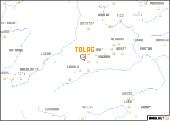
Tolag (Mountain, Philippines)Tolag is a town in the Mountain region of Philippines. An overview map of the region around Tolag is displayed below.
regional and 3d topo map of Tolag, Philippines ::
Tolag airports ::
The nearest airport is BAG - Baguio, located 101.9 km south west of Tolag.
Nearby towns ::
Iyahan (0.8km south east) //
Pitop (0.8km south east) //
Fianao (0.8km south east) //
Teing (1.7km north east) //
Oboob (2.3km south) //
Sacqui (2.4km south west) //
Tonglayan (2.4km south west) //
Ugtong (2.5km east) //
Patang (2.5km east) //
Toalling (2.5km east) //
Litiong (2.5km east) //
Alonogan (2.6km north east) //
Tugwachan (3.3km south east) //
Lonalo (3.4km south west) //
Apat (4.3km east) //
Fiatitio (4.3km east) //
Lunugan (4.3km east) //
Sagapa (4.3km east) //
Alunupan (4.3km east) //
Tochey (4.5km east) //
Nanlingan (4.5km east) //
Puyaao (4.5km east) //
Cadaclan (5.3km south west) //
Balañgao (6.1km north east) //
Natonin (6.2km east) //
Logab (6.4km west) //
Mayatap (7.1km north) //
Panag (6.9km north east) //
Aliawan (8.0km north east) //
[all distances 'as the bird flies' and approximate] 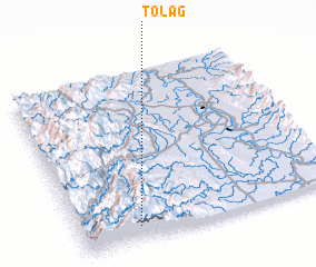 Places with similar names to Tolag, Philippines ::
Disclaimer :: Information on this page comes without warranty of any kind |
||
|
Where is Tolag? Elevation and coordinates ::
Latitude (lat): 17°5'10"N Longitude (lon): 121°13'36"E
Elevation (approx.): 959m (map arrows pan, magnifying glasses zoom) |
||
|
Visiting Tolag? Hotel/Accommodation ::
Book a hotel in Tolag Travel Guide ::
Buy a travel guide for Philippines rental cars ::
car rental offers GPS waypoint ::
download a GPX waypoint (PoI) of Tolag for your GPS receiver
|
||