|
search place name
|
||
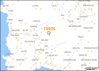
Toong (Batangas, Philippines)Toong is a town in the Batangas region of Philippines. An overview map of the region around Toong is displayed below.
regional and 3d topo map of Toong, Philippines ::
Toong airports ::
The nearest airport is MNL - Manila Ninoy Aquino Intl, located 58.5 km north east of Toong.
Nearby towns ::
Bolboc (3.2km south west) //
Bayudbud (3.3km north west) //
Mataywanac (3.9km west) //
Banilad (3.9km north west) //
Caylungan (4.0km north) //
Magahis (4.3km south west) //
Acle (4.3km south west) //
Dao (5.2km south) //
Calan (5.3km south) //
Sabang (5.1km west) //
Talon (5.2km west) //
Luntal (5.2km west) //
Tuy (5.3km south west) //
Tuyontuyon (5.7km south west) //
Bilaran (5.8km west) //
Sugod (6.0km south) //
Sabang (6.1km west) //
Tumalim (6.3km north west) //
Lumbangan (7.1km west) //
Putol (7.2km south west) //
Guinhawa (7.3km south west) //
Dao (7.7km south) //
Palico (7.7km west) //
Palincaro (7.9km south west) //
Aga (8.2km north east) //
Bolboc (8.3km south west) //
Viga (8.4km south) //
Gumalas (8.6km south) //
Calantas (8.8km south) //
[all distances 'as the bird flies' and approximate] 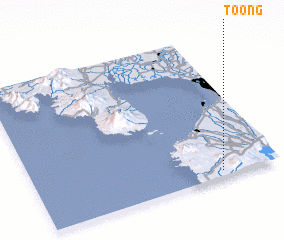 Places with similar names to Toong, Philippines ::
Disclaimer :: Information on this page comes without warranty of any kind |
||
|
Where is Toong? Elevation and coordinates ::
Latitude (lat): 14°2'33"N Longitude (lon): 120°45'49"E
Elevation (approx.): 139m (map arrows pan, magnifying glasses zoom) |
||
|
Visiting Toong? Hotel/Accommodation ::
Book a hotel in Toong Travel Guide ::
Buy a travel guide for Philippines rental cars ::
car rental offers GPS waypoint ::
download a GPX waypoint (PoI) of Toong for your GPS receiver
|
||