|
search place name
|
||
Tugatog (Bulacan, Philippines)Tugatog is a town in the Bulacan region of Philippines. An overview map of the region around Tugatog is displayed below.
regional and 3d topo map of Tugatog, Philippines ::

Tugatog airports ::
The nearest airport is MNL - Manila Ninoy Aquino Intl, located 47.3 km south of Tugatog.
Other airports nearby include BAG - Baguio (165.0 km north), Nearby towns ::
Angat (1.3km south east) //
Santa Lucia (1.3km east) //
Binagbag (1.5km north) //
Baybay (2.0km east) //
Marungko (2.1km north west) //
Banaban (2.3km east) //
Laog (2.3km south east) //
Sabang (2.8km north west) //
Tabok (3.4km west) //
Matiktik (3.8km south east) //
Maronquillo (3.9km north west) //
Norzagaray (4.1km south east) //
Indonacion (4.1km west) //
Libo (4.3km south east) //
Tayang Tayang (4.4km west) //
Sibul (4.9km east) //
Bagong Barrio (5.1km east) //
Bukol (5.1km east) //
Talaksan (5.3km north west) //
Lauang (5.4km south east) //
Bituñgol (6.0km south) //
Niugan (6.1km west) //
Maasim (6.4km north) //
Santol (6.3km south east) //
San Rafael (6.5km west) //
Pinakpinakan (6.8km north west) //
San Agustin (6.8km north west) //
Kakarong (6.9km south west) //
Sangat (7.0km east) //
[all distances 'as the bird flies' and approximate] 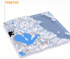 Places with similar names to Tugatog, Philippines ::
Disclaimer :: Information on this page comes without warranty of any kind |
||
|
Where is Tugatog? Elevation and coordinates ::
Latitude (lat): 14°56'9"N Longitude (lon): 121°1'16"E
Elevation (approx.): 37m (map arrows pan, magnifying glasses zoom) |
||
|
Visiting Tugatog? Hotel/Accommodation ::
Book a hotel in Tugatog Travel Guide ::
Buy a travel guide for Philippines rental cars ::
car rental offers GPS waypoint ::
download a GPX waypoint (PoI) of Tugatog for your GPS receiver
|
||