|
search place name
|
||
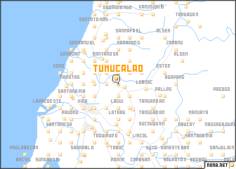
Tumucalao (Ilocos Norte, Philippines)Tumucalao is a town in the Ilocos Norte region of Philippines. An overview map of the region around Tumucalao is displayed below.
regional and 3d topo map of Tumucalao, Philippines ::
Tumucalao airports ::
The nearest airport is BAG - Baguio, located 205.7 km south of Tumucalao.
Nearby towns ::
Buyon (0.0km north) //
Vintar (1.0km east) //
Pait (1.9km south) //
Pasaqui (1.9km south) //
Calutit (1.8km west) //
Teppang (1.8km west) //
Pandayocan (1.8km west) //
San Alberto (1.9km north) //
Margaay (2.6km south east) //
Bani (2.6km north west) //
Calioet (2.6km north west) //
Cabolalaan (2.6km north west) //
Tubburan (2.6km north west) //
Pasñga (2.6km north west) //
Duripes (2.6km north west) //
Paninaan (2.6km north west) //
Pacis (2.6km north west) //
Bugas (2.6km north west) //
Salpad (2.6km north east) //
Bacarra (3.0km north west) //
Lagui (3.7km south) //
Casili (3.5km west) //
Curarig (3.5km west) //
Pasiocan (3.5km west) //
Barit (3.8km west) //
Baldias (4.1km south west) //
Bulangon (4.0km south west) //
Ñgibab (4.0km south west) //
Bannua (4.1km south east) //
[all distances 'as the bird flies' and approximate]  Places with similar names to Tumucalao, Philippines ::
Disclaimer :: Information on this page comes without warranty of any kind |
||
|
Where is Tumucalao? Elevation and coordinates ::
Latitude (lat): 18°14'0"N Longitude (lon): 120°38'0"E
Elevation (approx.): 24m (map arrows pan, magnifying glasses zoom) |
||
|
Visiting Tumucalao? Hotel/Accommodation ::
Book a hotel in Tumucalao Travel Guide ::
Buy a travel guide for Philippines rental cars ::
car rental offers GPS waypoint ::
download a GPX waypoint (PoI) of Tumucalao for your GPS receiver
|
||