|
search place name
|
||
Uso (Ilocos Sur, Philippines)Uso is a town in the Ilocos Sur region of Philippines. An overview map of the region around Uso is displayed below.
regional and 3d topo map of Uso, Philippines ::

Uso airports ::
The nearest airport is BAG - Baguio, located 67.7 km south of Uso.
Nearby towns ::
Ida (1.9km north) //
Namatingan (2.6km north east) //
Suyo (2.5km west) //
Kimposa (3.5km west) //
Libong (3.5km west) //
Nacugang (3.7km south) //
Oso (3.7km south) //
Mapalina (3.7km north) //
Paaraban (3.9km north east) //
Beto (4.0km north west) //
Bulala (4.1km south east) //
Lubnac (4.1km north west) //
Quinvuctut (5.3km north) //
Butbutigui (5.6km east) //
Abaccan (5.8km north) //
Singlan (5.8km north) //
Marmarsang (5.8km south) //
Lepanan (5.8km south) //
Palasipas (6.6km south west) //
Butac (6.5km south east) //
Tagpen (6.5km south east) //
Guinosod (6.6km north east) //
Duquis (6.6km north east) //
San Ramon (6.6km north east) //
Cabugao (7.2km south west) //
Sigay (7.6km north east) //
San Elias (7.6km north) //
Tobo (8.0km south east) //
Batangen (8.2km north east) //
[all distances 'as the bird flies' and approximate] 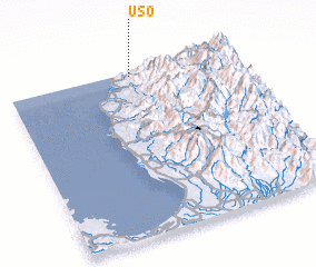 Places with similar names to Uso, Philippines ::
Disclaimer :: Information on this page comes without warranty of any kind |
||
|
Where is Uso? Elevation and coordinates ::
Latitude (lat): 16°59'0"N Longitude (lon): 120°33'0"E
Elevation (approx.): 384m (map arrows pan, magnifying glasses zoom) |
||
|
Visiting Uso? Hotel/Accommodation ::
Book a hotel in Uso Travel Guide ::
Buy a travel guide for Philippines rental cars ::
car rental offers GPS waypoint ::
download a GPX waypoint (PoI) of Uso for your GPS receiver
|
||