|
search place name
|
||
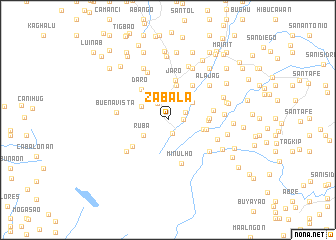
Zabala (Leyte, Philippines)Zabala is a town in the Leyte region of Philippines. An overview map of the region around Zabala is displayed below.
regional and 3d topo map of Zabala, Philippines ::
Zabala airports ::
The nearest airport is TAC - Tacloban Daniel Z Romualdez, located 29.0 km east of Zabala.
Other airports nearby include NOP - Masbate Mactan Cebu Intl (127.4 km south west), BCD - Bacolod (209.4 km west), DGT - Dumaguete (257.7 km south west), Nearby towns ::
Canhandugan (1.6km south) //
Villapaz (1.7km east) //
Macanip (2.1km north east) //
Uguia (2.1km north west) //
Malobago (2.5km north) //
Ruba (3.2km south west) //
Tinambacan (3.3km north west) //
San Roque (3.4km north east) //
San Agustin (4.0km north) //
Ilawod (4.0km north) //
Bi-as (4.0km north) //
Burabud (4.0km north) //
Parasan (4.0km north) //
Badiang (4.1km east) //
Sarisari (4.3km east) //
Hibunawon (4.4km east) //
Jaro (4.5km north) //
Daro (4.5km north west) //
Iphag (4.5km east) //
Ylandoguia (4.7km north east) //
Buri (4.7km north east) //
Bonglayon (4.9km south west) //
Minulho (5.1km south) //
Pange (5.1km east) //
Lainab (5.7km north west) //
Buenavista (5.7km west) //
Longbiahay (5.8km south east) //
Omotot (5.8km south west) //
Tingib (5.9km east) //
[all distances 'as the bird flies' and approximate]  Places with similar names to Zabala, Philippines ::
Disclaimer :: Information on this page comes without warranty of any kind |
||
|
Where is Zabala? Elevation and coordinates ::
Latitude (lat): 11°8'55"N Longitude (lon): 124°46'30"E
Elevation (approx.): 176m (map arrows pan, magnifying glasses zoom) |
||
|
Visiting Zabala? Hotel/Accommodation ::
Book a hotel in Zabala Travel Guide ::
Buy a travel guide for Philippines rental cars ::
car rental offers GPS waypoint ::
download a GPX waypoint (PoI) of Zabala for your GPS receiver
|
||