|
search place name
|
||
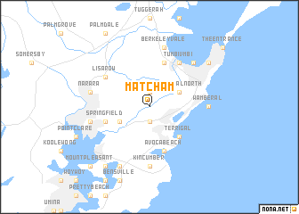
Matcham (New South Wales, Australia)Matcham is a town in the New South Wales region of Australia. An overview map of the region around Matcham is displayed below.
regional and 3d topo map of Matcham, Australia ::
Matcham airports ::
The nearest airport is RCM - Richmond, located 62.5 km west of Matcham.
Other airports nearby include SYD - Sydney Intl (62.8 km south), BWU - Sydney Bankstown (68.9 km south west), CDU - Camden (96.7 km south west), Nearby towns ::
Erina East (1.9km south) //
Holgate (1.9km north) //
Wamberal North (3.6km north east) //
Erina (3.6km south west) //
Terrigal (4.8km south east) //
Avoca Beach (5.8km south) //
Ourimbah (5.8km north) //
Springfield (5.0km west) //
Tumbi Vmbi (6.4km north east) //
Lisarow (5.9km north west) //
Wamberal (6.2km east) //
Kincumber (7.4km south) //
Berkeley Vale (7.6km north) //
Gosford (6.5km west) //
East Gosford (6.5km west) //
Narara (6.5km west) //
Killarney (7.2km north east) //
Kincumber South (8.0km south west) //
Long Jetty (8.3km north east) //
Davistown (8.7km south west) //
Mount Pleasant (9.7km south west) //
[all distances 'as the bird flies' and approximate]  Places with similar names to Matcham, Australia ::
// Mitchimi (CM)
// Müdesheim (DE)
// Mitcham (NZ)
// Matshumbi (CD)
// Mitshumbi (CD)
// Matsioumba (GA)
// Mitcham (JM)
// Mutechêmua (MZ)
// Mietesheim (FR)
// Mitcham (AU)
Disclaimer :: Information on this page comes without warranty of any kind |
||
|
Where is Matcham? Elevation and coordinates ::
Latitude (lat): 33°25'0"S Longitude (lon): 151°25'0"E
Elevation (approx.): 22m (map arrows pan, magnifying glasses zoom) |
||
|
Visiting Matcham? Hotel/Accommodation ::
Book a hotel in Matcham Travel Guide ::
Buy a travel guide for Australia rental cars ::
car rental offers GPS waypoint ::
download a GPX waypoint (PoI) of Matcham for your GPS receiver
|
||