|
search place name
|
||
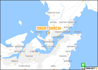
Nagatomachi (Yamaguchi, Japan)Nagatomachi is a town in the Yamaguchi region of Japan. An overview map of the region around Nagatomachi is displayed below.
regional and 3d topo map of Nagatomachi, Japan ::
Nagatomachi airports ::
The nearest airport is KKJ - New Kitakyushu, located 15.9 km south east of Nagatomachi.
Other airports nearby include UBJ - Yamaguchi Ube (33.5 km east), FUK - Fukuoka (59.1 km south west), OIT - Oita (92.2 km south east), IKI - Iki (107.0 km west), Nearby towns ::
Izakichō (0.0km north) //
Amanogōchō (0.0km north) //
Enoura (1.9km south) //
Hommura-Ushiroyamachō (1.9km south) //
Yamatochō (1.9km south) //
Utsuishi (2.4km south west) //
Dannouramachi (3.1km east) //
Shimonoseki (3.1km east) //
Tanokubichō (3.7km south) //
Watase (3.1km west) //
Hatabu (4.0km north east) //
Kuzuhachō (3.6km south east) //
Komorie (4.8km south east) //
Moji (4.6km east) //
Nishi-kaigandōri (4.6km east) //
Dairi-shimmachi (5.6km south) //
Maeda (5.0km east) //
Yasuokamachi (7.4km north) //
Iwakuro (6.4km east) //
Nobuyukichō (7.6km north) //
Chōfu-Miyazakichō (7.2km north east) //
Ōsakamachi (8.0km south west) //
Kokura (8.0km south west) //
Tamachi (8.7km south west) //
Itabitsu (8.7km south west) //
Saiemba (8.7km south west) //
Hata (9.6km south east) //
[all distances 'as the bird flies' and approximate]  Places with similar names to Nagatomachi, Japan ::
// Nikatamachi (JP)
Disclaimer :: Information on this page comes without warranty of any kind |
||
|
Where is Nagatomachi? Elevation and coordinates ::
Latitude (lat): 33°57'0"N Longitude (lon): 130°55'0"E
(map arrows pan, magnifying glasses zoom) |
||
|
Visiting Nagatomachi? Hotel/Accommodation ::
Book a hotel in Nagatomachi Travel Guide ::
Buy a travel guide for Japan rental cars ::
car rental offers GPS waypoint ::
download a GPX waypoint (PoI) of Nagatomachi for your GPS receiver
|
||