|
search place name
|
||
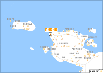
Ohama (Okinawa, Japan)Ohama is a town in the Okinawa region of Japan. An overview map of the region around Ohama is displayed below.
regional and 3d topo map of Ohama, Japan ::
Ohama airports ::
The nearest airport is DNA - Kadena Ab, located 38.1 km south of Ohama.
Other airports nearby include OKA - Naha (59.0 km south west), RNJ - Yoron (65.2 km north east), UEO - Kumejima (121.8 km west), TKN - Tokunoshima (161.5 km north east), Nearby towns ::
Tōbaru (0.0km north) //
Usambaru (0.0km north) //
Kitazato (1.0km north east) //
Urasaki (1.3km south east) //
Hamamoto (1.6km south) //
Shinzato (2.0km north east) //
Jahana (1.9km south east) //
Katsuu (2.0km east) //
Bise (2.2km north) //
Yabiku (2.9km south) //
Gushiken (2.7km north east) //
Higashihara (3.5km south) //
Motobu (3.5km south) //
Ufugumui (3.7km south) //
Agariuebaru (3.3km east) //
Ufudo (3.5km east) //
Toguchi (4.1km south east) //
Imadomari (4.5km north east) //
Manna (5.0km south east) //
Sesoko (5.2km south west) //
Hamasaki (5.6km south) //
Namisato (5.4km south east) //
Kaneshi (5.2km east) //
Sankeimō (5.8km south) //
Nakaoshi (5.3km east) //
Shoshi (5.6km east) //
Sakimotobu (6.6km south) //
Yanaza (6.2km south east) //
Yonamine (6.1km east) //
[all distances 'as the bird flies' and approximate]  Places with similar names to Ohama, Japan ::
Disclaimer :: Information on this page comes without warranty of any kind |
||
|
Where is Ohama? Elevation and coordinates ::
Latitude (lat): 26°41'0"N Longitude (lon): 127°53'0"E
Elevation (approx.): 49m (map arrows pan, magnifying glasses zoom) |
||
|
Visiting Ohama? Hotel/Accommodation ::
Book a hotel in Ohama Travel Guide ::
Buy a travel guide for Japan rental cars ::
car rental offers GPS waypoint ::
download a GPX waypoint (PoI) of Ohama for your GPS receiver
|
||