|
search place name
|
||
Shimotsu (Wakayama, Japan)Shimotsu is a town in the Wakayama region of Japan. An overview map of the region around Shimotsu is displayed below.
regional and 3d topo map of Shimotsu, Japan ::

Shimotsu airports ::
The nearest airport is TKS - Tokushima, located 50.3 km west of Shimotsu.
Other airports nearby include SHM - Nanki-shirahama Nanki Shirahama (52.5 km south), ITM - Osaka Intl (80.5 km north), TAK - Takamatsu (105.4 km west), OKJ - Okayama (139.5 km north west), Nearby towns ::
Karekawa (1.5km west) //
Mukaiyama (2.4km north west) //
Kominami (2.4km north east) //
Mera (2.4km north west) //
Shiotsu (4.0km north) //
Ōsaki (4.0km north) //
Minoshima (3.6km south west) //
Tatsugahama (5.0km west) //
Kitaminato (5.0km west) //
Wakayama (5.6km west) //
Kainan (7.2km north east) //
Nataka (7.2km north east) //
Yuasa (8.0km south east) //
[all distances 'as the bird flies' and approximate] 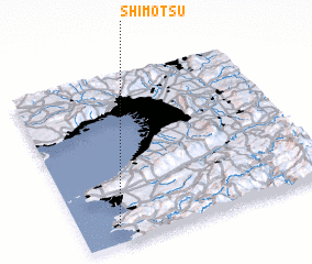 Places with similar names to Shimotsu, Japan ::
// Shumbāţis (EG)
// Shembetsay (KZ)
// Hsia-ma-ts'o (TW)
// Chomutice (CZ)
// Shimotsui (JP)
// Chiembetsu (JP)
// Shumbetsu (JP)
// Shumbetsu (JP)
// Chamboutes (FR)
// Chaumots (FR)
Disclaimer :: Information on this page comes without warranty of any kind |
||
|
Where is Shimotsu? Elevation and coordinates ::
Latitude (lat): 34°6'0"N Longitude (lon): 135°9'0"E
Elevation (approx.): 208m (map arrows pan, magnifying glasses zoom) |
||
|
Visiting Shimotsu? Hotel/Accommodation ::
Book a hotel in Shimotsu Travel Guide ::
Buy a travel guide for Japan rental cars ::
car rental offers GPS waypoint ::
download a GPX waypoint (PoI) of Shimotsu for your GPS receiver
|
||